![]()
![]()
![]()
It's time, finally, to leave the Bryce Canyon area. I must move on, though I do so somewhat reluctantly. Every day so far I saw, explored, did, something new; not the usual course on these Thanksgiving trips. It has been truly wonderful. But, I have other new places to see and explore, to record in my memory and on film, and to share with you all via the internet. I'm heading north today, up to Capitol Reef NP. From there I plan to head east and south to Natural Bridges NM, and from there...?
The temperature is again mild as I hit the road. The sun is out, but the sky is filled with clouds, harbingers of an approaching winter storm. It's going to snow in Utah tomorrow; it's just a question of where and how much. It looks like I most likely won't get dumped on, but... Well, it's been pretty darned good weather so far and I'm prepared for the worst so, "Bring it on!".
Back towards Escalante (founded in 1878) and beyond. I eventually reach the town of Boulder, an attractive, quaint little place, nestled at the foot of Boulder Mountain, that is home to the Anasazi Indian Village State Park and the jumping off place for the Burr Trail, a road which leads one to some of the more remote wonders to be seen in the area. No time to stop here today or to drive down the Burr Trail; it's getting late and the shadows are disappearing as the cloud layer thickens in front of the sun.
I start the ascent of Boulder Mountain. When I first did this route, 18 years ago, it was dirt and gravel, very rough and slow going. Today it's easy cruising as I wind up the mountainside. Almost immediately I pass the 8000 ft. mark. A little bit further up I start to see some aspens, then more, then even more. Soon there are aspens all around, huge groves anchoring the mountain's flanks. It must be an artist's and photographer's dream when they all turn gold in the fall. Now though they are bare - silent, shorn sentinels of the coming winter cold.
 I
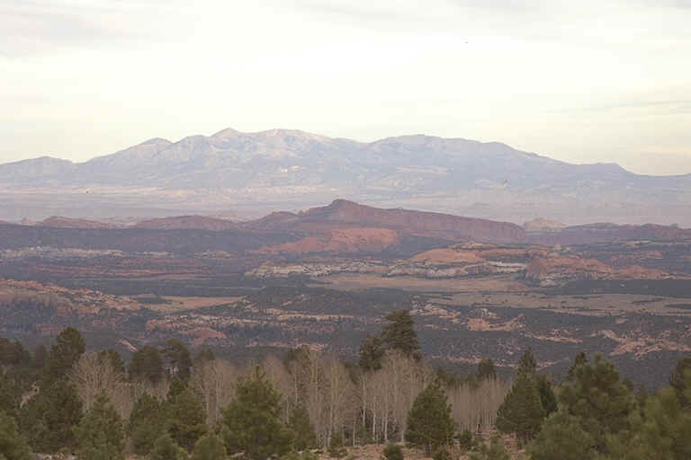
stop at the Homestead Overlook near the road's apogee over Boulder Mountain,
at an elevation of about 9500 feet. In front of me is an awesome tableau of
the area's geologic features. The Henry Mountains, whose peaks are bare of
their normal, this time of year, snowy mantle, loom up large on my left as
they march south, fading into the distant mist. In front of them I can see
the large, blocky, red rocks of Capitol Reef and the Waterpocket Fold as it
follows the Henry Mtns. down towards Lake Powell. To my right is the
Kaiparowits Plateau which we traversed last Saturday. The town of Boulder is
just visible to the right and below. In front are various multi-colored
cliffs and canyons, behind are just visible the Circle Cliffs. The Burr Trail
which takes you through one of the prettiest little canyons I know, Long
Canyon, can be seen also as it wanders toward the Waterpocket Fold. The
rounded profile of Navajo Mountain is barely discernable way off in the
distance.
I
stop at the Homestead Overlook near the road's apogee over Boulder Mountain,
at an elevation of about 9500 feet. In front of me is an awesome tableau of
the area's geologic features. The Henry Mountains, whose peaks are bare of
their normal, this time of year, snowy mantle, loom up large on my left as
they march south, fading into the distant mist. In front of them I can see
the large, blocky, red rocks of Capitol Reef and the Waterpocket Fold as it
follows the Henry Mtns. down towards Lake Powell. To my right is the
Kaiparowits Plateau which we traversed last Saturday. The town of Boulder is
just visible to the right and below. In front are various multi-colored
cliffs and canyons, behind are just visible the Circle Cliffs. The Burr Trail
which takes you through one of the prettiest little canyons I know, Long
Canyon, can be seen also as it wanders toward the Waterpocket Fold. The
rounded profile of Navajo Mountain is barely discernable way off in the
distance.
As I drop down off of Boulder Mountain the features of Capitol Reef start looming, huge blocks of mostly reddish stone, mixed with layers of grays and whites. Finally, Scenic Byway Rt. 12 ends at Scenic Byway Rt. 24 near the very small town of Torrey, Utah. I turn right, east, towards Capitol Reef. There are quite a few more business here since the last time I was through here. Before, there was only one little motel open this time of year. Now there are several, including a Best Western. Progress!
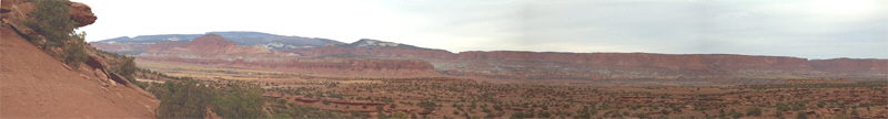
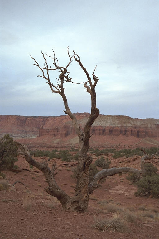
I drive on through the mostly brick-red to brownish-red landscape. Seeing a dirt track on my right I jump off road and drive in a few hundred yards until I come to a scenic spot adorned with huge and interestingly-shaped rocks. I get out my tripod and take a series of pictures around the horizon, a panorama of the massive edifices standing quiet sentry in the park. To prove that I'm not just making this all up and taking credit for someone else's picture, I also snap one of me standing next to my truck - the explorer and the Explorer!
Back on road I stop often to take pictures as the light is fading quickly; I took my time getting here and it's almost dark. I can see several distinct layers here. The topmost, the orange-red rocks of the Wingate Formation, formed from an ancient sandy desert, is the thickest and the smoothest looking. It tends to break off in large, blocky chunks. In some of the huge vertical walls of this layer I can see semi-circular fractures, the beginnings of an arch? At many places, its topped by another more recent layer of white sandstone. The next layer, the gray and light brown rocks of the Chinle Formation, volcanic ash from Arizona, is a striking contrast to the other, darker layers above and below. It looks soft and eroded, almost badlands-like. The bottom, brick-red layers of the Moenkopi Formation, former tidal mudflats, exhibit a high degree of layering, are rounded, and stick out from the layers above. It look as if they've been squeezed out from the heavy burden of rock above.
 I
drive past the visitor center which is at the site of an old Mormon pioneer
settlement, Fruita. The orchards planted by the pioneers are still active and
visitors can pick fruit during harvest time. From here one can take a short,
scenic drive south. Along this road you can park and take a short hike
through a canyon and view pioneer graffiti scratched into the walls above
(I've done that before - worth it if you're in the area). As I drive past
the orchards I see a momma deer with her two fawns (Awwwww). Just
beyond I make a quick stop to take a gander at some petroglyphs left by some
even older settlers in the area, the Anasazi. I see a women taking some
serious photographs of some other petroglyphs down the way a bit and up
higher. I wonder if she's on official business or has permission to be up
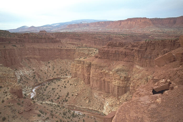
there? Hmmmm. The road is now following the Fremont River which has cut the
way through the narrow canyon here, the walls of which are a 1000 feet or
more above me as I continue eastward.
I
drive past the visitor center which is at the site of an old Mormon pioneer
settlement, Fruita. The orchards planted by the pioneers are still active and
visitors can pick fruit during harvest time. From here one can take a short,
scenic drive south. Along this road you can park and take a short hike
through a canyon and view pioneer graffiti scratched into the walls above
(I've done that before - worth it if you're in the area). As I drive past
the orchards I see a momma deer with her two fawns (Awwwww). Just
beyond I make a quick stop to take a gander at some petroglyphs left by some
even older settlers in the area, the Anasazi. I see a women taking some
serious photographs of some other petroglyphs down the way a bit and up
higher. I wonder if she's on official business or has permission to be up
there? Hmmmm. The road is now following the Fremont River which has cut the
way through the narrow canyon here, the walls of which are a 1000 feet or
more above me as I continue eastward.
 The
sun is now set behind Boulder Mountain as I leave the park's boundaries, but
in the twilight I can see that the colors have changed to more whites and
yellows. Also the walls of the canyon have dropped significantly in height.
Looking to my left I am struck by the bright pink wisps in the traces. It
looks like it's going to be another beautiful sunset. Too bad I'm not heading
west. A few minutes later, looking back - "Whoa! Careful, one lane per
customer!" - I see that the sky is alight again with a very bright
orange and pink glow, so bright that I think I can see the reflection of it
off of some bluffs in front of me, bluffs which were essentially dark and
featureless just a few moments ago. Spectacular!
The
sun is now set behind Boulder Mountain as I leave the park's boundaries, but
in the twilight I can see that the colors have changed to more whites and
yellows. Also the walls of the canyon have dropped significantly in height.
Looking to my left I am struck by the bright pink wisps in the traces. It
looks like it's going to be another beautiful sunset. Too bad I'm not heading
west. A few minutes later, looking back - "Whoa! Careful, one lane per
customer!" - I see that the sky is alight again with a very bright
orange and pink glow, so bright that I think I can see the reflection of it
off of some bluffs in front of me, bluffs which were essentially dark and
featureless just a few moments ago. Spectacular!
It's dark as I pull into Hanksville - time to make a decision. The last and only time that I was through here, 18 years ago, my brother Carl and I stopped here for dinner, then drove south to Natural Bridges, where we couldn't see caca of course, then on to Canyonlands. The road is marked as scenic, and I would hate to miss such spectacular(?) scenery again so... Ok, time to stop for the night. So I gas up and bed down for the night in a nice little hotel next door to the gas station. Let's hope for cooperative weather and an early start tomorrow when I head towards Natural Bridges NM, this time, hopefully, to actually see the bridges. In the meantime I think I'll try to take a look at all the literature and maps I have on the area. Perhaps I can figure out where I'm going as I head into new territory.
Chris
.jpg)