![]()
![]()
![]()
Oh boy! Another beautiful day. Bright, blue sky. Warm, fresh, sun-filled air. I am so lucky. I'm going to run down to Kanab today (about 70 miles) to see if I can pick up a new lens cap (I lost my old one during the Yup hike) and to get another DC-to-AC inverter. The one I bought just 3 months ago crapped out and I need one to run the laptop (so I can post all these wonderful stories). I get on the road 10ish and start towards Kanab. Driving south on 89 I can see the meandering course of the Sevier River on my left. Behind it are expansive meadows sweeping up to huge red-colored cliffs. Looks like it would be a nice place to have a getaway home. I wonder what land goes for around here?
 I
pass the turnoff to Zion and the turnoff to Coral Pink Sand Dunes. Tempting.
Very tempting. But I have other plans. I get to Kanab and after visiting
Radio Shack and Ace Hardware first I find an inverter at NAPA Auto Parts.
Yayy! I then roll over to a camera store and find what I need there. Nice
little town Kanab. I get some gas and head west out of town, still on 89. The
Vermillion Cliffs are the main formation here and they are resplendent today.
About 10 miles out I turn left onto Johnson Canyon Road. The initial section
is nicely paved as I head north towards the White Cliffs which are the next
in succession (Vermillion, White, Gray, Pink).
I
pass the turnoff to Zion and the turnoff to Coral Pink Sand Dunes. Tempting.
Very tempting. But I have other plans. I get to Kanab and after visiting
Radio Shack and Ace Hardware first I find an inverter at NAPA Auto Parts.
Yayy! I then roll over to a camera store and find what I need there. Nice
little town Kanab. I get some gas and head west out of town, still on 89. The
Vermillion Cliffs are the main formation here and they are resplendent today.
About 10 miles out I turn left onto Johnson Canyon Road. The initial section
is nicely paved as I head north towards the White Cliffs which are the next
in succession (Vermillion, White, Gray, Pink).
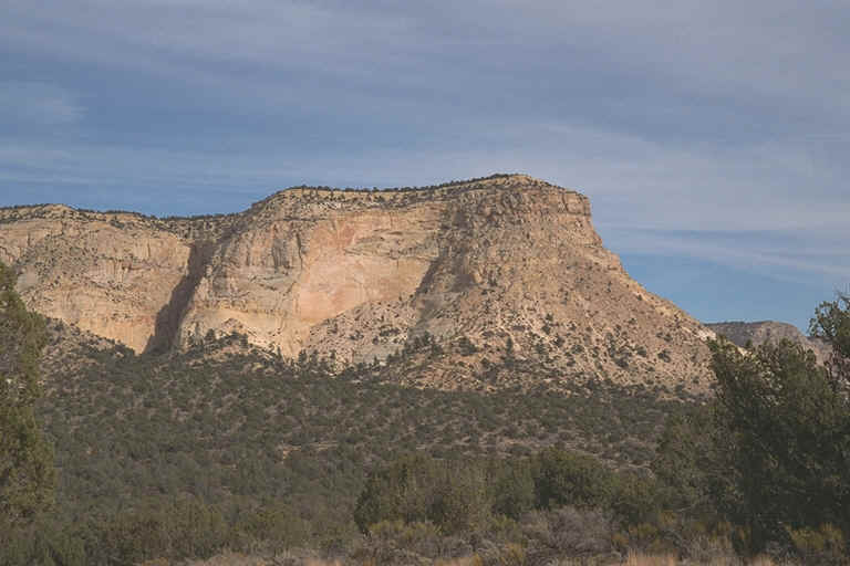
I blow by a marked dirt road, stop, reverse, look at the sign, and decide to check it out. The road branches off in several directions. I decide to take the leftmost because it appears to head towards a part of the White Cliffs just to the northeast. The track is very sandy, deeply tracked, and initially goes uphill. So I go spinning, slipping, and sliding on my way. "Ride 'em cowboy! Yeehaw!" It's a fun ride as I fight my way up the hill. I end up going a few miles in, enjoying it all the way. After getting a nice picture I slip and slide back to the main road and head north once again.
 After
a while the pavement ends at a Y and I take the right branch, Skutumpah Road.
I'm heading towards Willis Creek today to hike down a slot canyon. From the
split I have an easy, scenic drive of 26 miles. I'm among the Gray Cliffs now
which are gray with a greenish hue. These are mostly to my left. The White
Cliffs are to my right. After about 11 miles I pass Deer Creek Ranch
where you can buy your own little ranchette or just rent a place to chill for
awhile. The road to the upper level units continues on up into Bryce Canyon,
the back way, past Tropic Reservoir, ending at Rt. 12, just past Bryce Canyon
Pines. It's a fun trip coming down from Bryce, especially in the snow (ask
John Boy).
After
a while the pavement ends at a Y and I take the right branch, Skutumpah Road.
I'm heading towards Willis Creek today to hike down a slot canyon. From the
split I have an easy, scenic drive of 26 miles. I'm among the Gray Cliffs now
which are gray with a greenish hue. These are mostly to my left. The White
Cliffs are to my right. After about 11 miles I pass Deer Creek Ranch
where you can buy your own little ranchette or just rent a place to chill for
awhile. The road to the upper level units continues on up into Bryce Canyon,
the back way, past Tropic Reservoir, ending at Rt. 12, just past Bryce Canyon
Pines. It's a fun trip coming down from Bryce, especially in the snow (ask
John Boy).
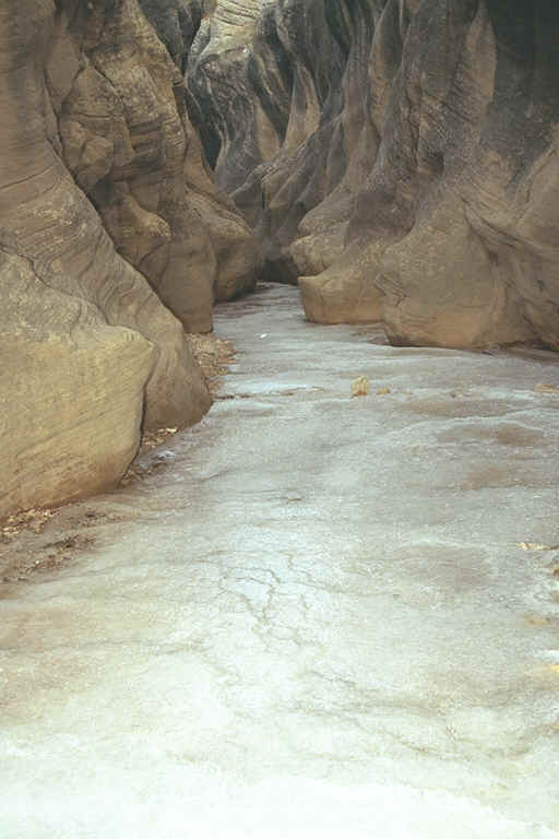
I finally arrive at Willis Creek and park off to the side. Just downstream the creek plunges about 8 feet straight down into a pool. I'm not getting in there, so I walk along the left bank a 100 feet or so and find a nice, easy way to get down into the creek bed. Almost immediately the creek starts slotting up, the walls about a dozen feet high. Cool! The waters of the creek are shallow and don't fully span the creek bed so I'm able to step easily around to keep my feet from getting wet (these boots are not waterproof, hell they're not even water-resistant, and I'm wearing cotton socks - let's hear it for Mr. Mountain Man).
I continue stepping around and over the streaming rivulets as the creek courses from side to side, the walls above steadily getting taller. The rocks here are a Halloween blend of blacks and oranges and are deeply scooped out at places, testament to the prodigious force of flooding waters. I round a bend and, "Oh oh!", the water spans the width of the canyon. Well, I'm able to carefully pick my way through and stay feet-dry, but I'm hoping this isn't an indication of the rest of the trip. There are patches of ice here and there so I know that water be cold!
After a bit the canyon opens up into a wide, gravelly area jammed with boulders, tree trunks and branches, and other detritus carried from high above (some of it originating in Bryce canyon actually). There is a sandy bench to one side which I head for as the walking should be easier there. At the start of the hike the air temperature was a tepid 58°, but here in the slot it's quite a bit cooler, especially when the walls close in and the sun is out of sight. Periodically though, I can feel little blasts of warm air which feel really good as my hands are starting to lose their circulation (they are so wimpy).
 I
can see ahead that the walls of the canyon, which continue to increase in
height, narrow again as the creek takes a turn to the left. I come around the
turn and stop. Ice city! What were patches is now the predominant feature. I
step gingerly, very gingerly through this section of about 30 feet, from one
side to the other side as I seek firm, dry surface to bear my weight. Whew! I
make it through without wetting my toesies. The next section has more
"dry" ground although there is still a lot of ice present. The
walls, which have become a brownish gray, are pretty narrow now, anywhere
from 5 to 15 apart, as I continue downstream. They are scarred with
horizontal striations, scratched from water-borne debris.
I
can see ahead that the walls of the canyon, which continue to increase in
height, narrow again as the creek takes a turn to the left. I come around the
turn and stop. Ice city! What were patches is now the predominant feature. I
step gingerly, very gingerly through this section of about 30 feet, from one
side to the other side as I seek firm, dry surface to bear my weight. Whew! I
make it through without wetting my toesies. The next section has more
"dry" ground although there is still a lot of ice present. The
walls, which have become a brownish gray, are pretty narrow now, anywhere
from 5 to 15 apart, as I continue downstream. They are scarred with
horizontal striations, scratched from water-borne debris.
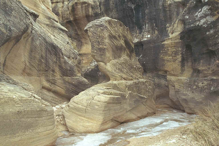
Again the canyon opens up and I smile at the blue sky above as the air warms a few degrees. Just downstream the creek again curves to the left and the canyon narrows, blocked by a massive, interestingly-shaped boulder about 15 feet tall by 20 feet wide. I pass the monolith on the left as that side is dry and sandy, make the turn and... "Damn! Where'd the water go?" I am looking at a field of ice as far as I can see downstream. The creek can be seen here and there, but there are no discernable "banks" on the side as before and in most places I have no idea which way the waters run. I'm thinking whether I should continue on or bail. After all, I've had a nice little hike so far. But, I've already been turned back by ^%!#& water once this trip so I decide to press on.
 I
step very carefully, along the right side which seems firmer. "Creak"
Carefully! "Crack" Carefully, carefully. Whew! made it - all
of 10 feet. Now I step into the middle and, "Squeeeak", the
ice bows under my weight, but holds. I step gingerly with my other foot and,
"Scruuunch", slide the back foot forward - it holds too. Slide.
Test. Slide. Wait. Slide. "Creeeeeeak" Slide. I slowly work my way
downstream. Sometimes I can use the close-by side wall for support, other
times I have no choice but to step and hope for the best. "Crunch,
crunch, crunch", the ice bows, bends, even breaks a little, yet
miraculously I remain dry down below. At one point I make a bridge of sorts
across to the other side (only about 10 feet) by tossing rocks across in a
line. It works! After a while I can spot which sections of ice are likely
to hold my weight (which I'm sure has increased a bit, Thanksgiving,
vacation, and all), and by the end of this long section I'm making fairly
quick progress - due to the thickness of the ice and my newly learned skill.
Step. Step. "Oh oh! Sliding! Sliding!! Can't stop!!!" "Whoa,
that ice is slippery!"
I
step very carefully, along the right side which seems firmer. "Creak"
Carefully! "Crack" Carefully, carefully. Whew! made it - all
of 10 feet. Now I step into the middle and, "Squeeeak", the
ice bows under my weight, but holds. I step gingerly with my other foot and,
"Scruuunch", slide the back foot forward - it holds too. Slide.
Test. Slide. Wait. Slide. "Creeeeeeak" Slide. I slowly work my way
downstream. Sometimes I can use the close-by side wall for support, other
times I have no choice but to step and hope for the best. "Crunch,
crunch, crunch", the ice bows, bends, even breaks a little, yet
miraculously I remain dry down below. At one point I make a bridge of sorts
across to the other side (only about 10 feet) by tossing rocks across in a
line. It works! After a while I can spot which sections of ice are likely
to hold my weight (which I'm sure has increased a bit, Thanksgiving,
vacation, and all), and by the end of this long section I'm making fairly
quick progress - due to the thickness of the ice and my newly learned skill.
Step. Step. "Oh oh! Sliding! Sliding!! Can't stop!!!" "Whoa,
that ice is slippery!"
The creek bed widens a bit and there is no longer a "sheet" of ice covering it. Now I can stride a bit more purposely. I look back upstream and I can't believe that I just came down "that"! Again the walls open up as Averett Canyon enters from the left, the creek veering to the right. I go to the juncture and look to my right, up Averett. It looks kind of slotty so I decide to check it out. I go a couple hundred feet and am greeted by the sight of a massive, and I mean massive, hugely massive boulder which has fallen from somewhere above and just totally jammed the entrance. Guess I won't be going that way!
Seeing as how it's almost 4:00 I guess I'd better head back. With a new found confidence I start marching back towards the truck. No pussyfooting this time, I just step, step, jump, step. I'm actually pretty good at picking out the firm sections of ice and even when I do crunch through, I'm moving so quickly that I hardly get wet (except for 1 or 2 missteps). I hike out in about half the time as going in and am soon back in the warm sunshine. My boots are soaked through, but it doesn't matter because I'm just driving now. Pretty neat adventure!
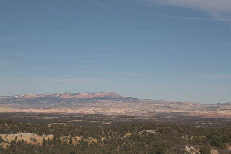
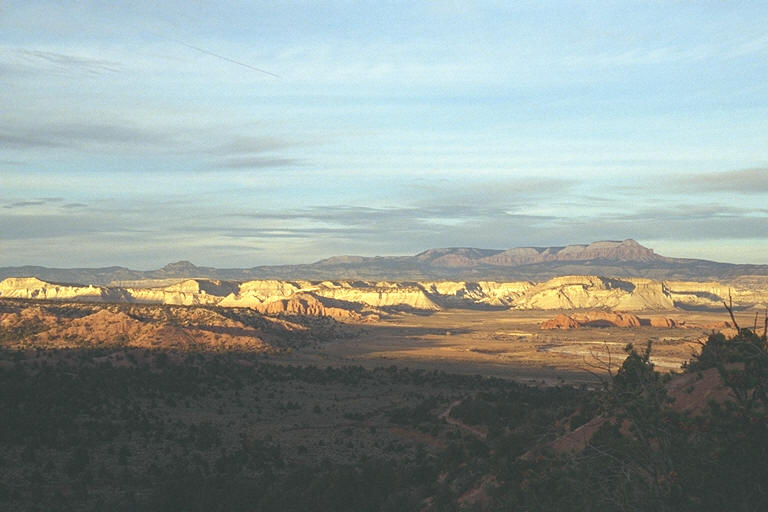 I
round a curve and my eyes are delighted with a sweeping, panoramic vista.
After being in the narrow confines of Willis Creek so recently, the
expansiveness is even more impressive than usual. Curving almost 180 degrees
are views of the Gray Cliffs. As you rotate from left to right you can see
them opening up to reveal the canyons contained within, just waiting to be
explored. On the left, behind them are the pinks and oranges of Bryce Canyon.
Center left, way up high and off in the distance, Powell Point is alive with
pink and white as the sun lights up it's protruding facade. Continuing on to
the right are more fine examples of the Pink Cliffs. All of this
anchored by the desert scrub and the greenish gray rocks, which portend the
rise of the Gray Cliffs, in the forefront.
I
round a curve and my eyes are delighted with a sweeping, panoramic vista.
After being in the narrow confines of Willis Creek so recently, the
expansiveness is even more impressive than usual. Curving almost 180 degrees
are views of the Gray Cliffs. As you rotate from left to right you can see
them opening up to reveal the canyons contained within, just waiting to be
explored. On the left, behind them are the pinks and oranges of Bryce Canyon.
Center left, way up high and off in the distance, Powell Point is alive with
pink and white as the sun lights up it's protruding facade. Continuing on to
the right are more fine examples of the Pink Cliffs. All of this
anchored by the desert scrub and the greenish gray rocks, which portend the
rise of the Gray Cliffs, in the forefront.
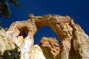
Another quick turn and I rapidly lose elevation as I drop down to cross Sheep Creek. Continuing on I can see its course dropping rapidly down into its own canyon, goldenrod-colored rocks topping the walls. A deer abruptly crosses the road in front of me, dashing off into the scrub. I'm making good time as I keep losing elevation, heading towards Bryce Valley. I find pavement again, Cottonwood Canyon Road, a few miles south of Cannondale. Turning right would take me to Kodachrome Basin State Park, just a few miles down. A bit beyond that you can find Grosvenor Arch. Those must be saved for another trip though; it's time to head "home" - back to the motel.
Enjoy your week,
Chris