![]()
![]()
![]()
The morning dawns bright and clear. It's chilly, but I bet it's going to warm up just nicely. So much for the snowstorm. I get on the road early, before that front gets a chance to find its way down here. Driving south on Rt. 95 (yes, that's Scenic Byway Rt. 95) I am delighted at the scenery around me. I am now on the other side of the Henry Mtns, which are lit up by the morning sun radiating brightly on their eastern flank. It's mostly flat right around me, but here and there I can see small buttes, long walls of eroded rock, and little canyons descending from the mountains. Far off in the distance to my left I spy some of the red and orange canyons over in Glen Canyon NRA and the Maze section of Canyonlands NP.
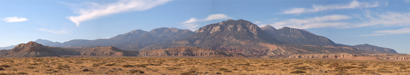
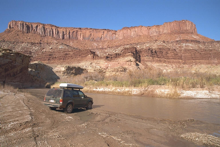
Just before I cross into Garfield County I check to my right and am struck by the sight of a long red cliff sitting at the base of one of the Henry Mtns. It's a sharp contrast to the cool greens, browns and grays of the range. I stop to take a panoramic series. If it comes out it should be an awesome shot. I blow by an unmarked dirt road. Checking my map I see that it is Poison Springs Canyon Road and that it penetrates into the Orange Cliffs section of Glen Canyon and the Maze section of Canyonlands. I don't have any information on the condition of the road so I don't know how far I can get in or even what's in there... and I'm traveling alone... and I really want to get some shots of the 3 bridges at Natural Bridges, so......
I decide to take Poison Springs Road. It's a beautiful day and I feel like a little adventure. I start down the road and come to a sign. "Dirty Devil River - 16 miles", "Sunset Pass - 35 miles", "Flint Trail - 45 miles". Looks like I'm going to be on this road for a while. I shift into 4WD and I head on in!
The going is a bit rocky so I have to go kind of slow, but initially it's pretty easy going. Almost immediately I'm down among the rounded red rocks of the washes and canyons here. After about 2 miles I come to a gate made out of barbed wire and a tree branch, closed with a loop of wire to the fence post. I open it, pass through, close it (as the little sign from the BLM asks me to do), and proceed on. A little bit ahead I spy a covey(?) of quails, about a dozen or so. The air is warming rapidly; its now 51° and 10:30. I keep splashing across the spring as we both take our individual, serpentine paths downward.
 I
am one with the spring! The road has merged with the stream course and I am
running through the water! It's not deep, but it's a bit soft in sections so
I keep up my momentum and hope I don't bog down. I can't go too fast though
because of the rocks and to make sure I don't come up to quickly on a
"bad" section. Slow, but not too slow! Let's adjust my seat so I
can see better in front. There. "Oops! Muddy spot!" "Just keep
going, steer into the slide... There you go!" "Phew!"
"This is a blast!" Now I'm back on "dry" land. Ok!
I
am one with the spring! The road has merged with the stream course and I am
running through the water! It's not deep, but it's a bit soft in sections so
I keep up my momentum and hope I don't bog down. I can't go too fast though
because of the rocks and to make sure I don't come up to quickly on a
"bad" section. Slow, but not too slow! Let's adjust my seat so I
can see better in front. There. "Oops! Muddy spot!" "Just keep
going, steer into the slide... There you go!" "Phew!"
"This is a blast!" Now I'm back on "dry" land. Ok!
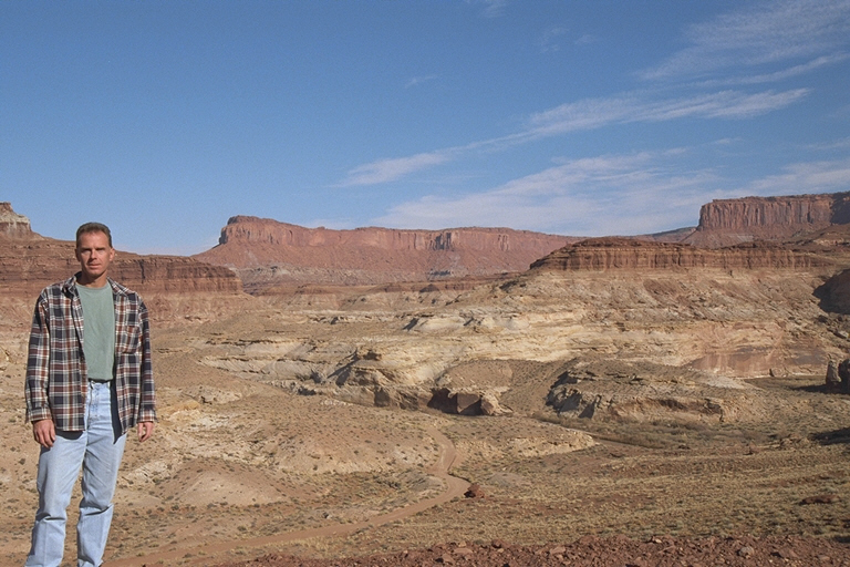
I come to a skidding stop! There's a cow in my way! (This is open range country.) We both stare at each other for a while. Who's going to blink first? We stare. I don't move. The cow doesn't move. It flicks its tail, I squirm in my seat. Neither of us yields. Finally, the great beast succumbs to my steely gaze and moves to the side. As I pass I note that it's a big cow. "Ummmm, steaaak!" I continue on and the way opens up, the road now steers away from the creek. The temperature has dropped a bit and I can see clouds above where before there was just clear sky. Storm a-comin'?
No storm. Looking to the west I see blue sky. After a while it clears right up and the temperature "soars" to the low 60's. Nice, nice, nice! I'm in and out of the water for a bit more, but then the streambed heads down a canyon and the road rises to the canyon top to the right. When I get up there I come to another "wired" gate. Open, close, proceed - I'm getting to be an expert at this. The going is now quicker as I stay above for a mile or so before dropping back down. The spring and road meet back up and I continue to cross and recross the creek, but now the bed is dry. Where did all the water go?
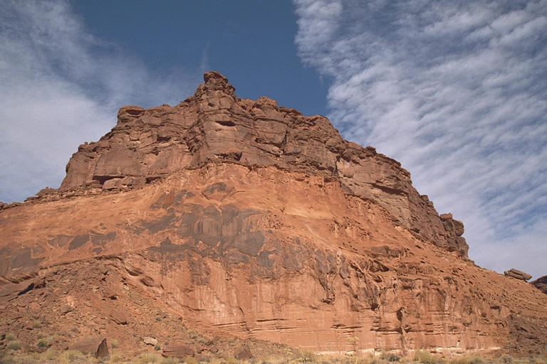
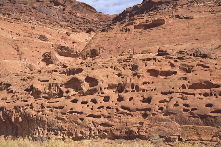 It's
fairly open as I chug along, but high above me the canyon walls soar. I see
buttes, balancing rocks, castles, spires, chimneys, mushroom caps, rock
falls, swiss cheese walls, small side canyons, huge side canyons, little
meadows of grass and trees, and more. It is just absolutely beautiful down
here. Good decision to come. Sometimes I can make pretty good time as it's
not so rocky, other times the way is very sandy so I slow down as I slide on
through. I'm losing elevation as I drop down towards the Dirty Devil River.
Now I'm at the level of the Moenkopi Formation composed of prominently
layered, brick-red rock. It erodes in such a fashion that it looks like a
bunch of platters of various sizes stacked one on top of another. At the top
is the orangey-red Wingate Formation. It fractures along vertical planes
leaving it with a colonnaded look, or sometimes looking like the side of a
grand building, often with an arch near the top where the rock split and fell
away.
It's
fairly open as I chug along, but high above me the canyon walls soar. I see
buttes, balancing rocks, castles, spires, chimneys, mushroom caps, rock
falls, swiss cheese walls, small side canyons, huge side canyons, little
meadows of grass and trees, and more. It is just absolutely beautiful down
here. Good decision to come. Sometimes I can make pretty good time as it's
not so rocky, other times the way is very sandy so I slow down as I slide on
through. I'm losing elevation as I drop down towards the Dirty Devil River.
Now I'm at the level of the Moenkopi Formation composed of prominently
layered, brick-red rock. It erodes in such a fashion that it looks like a
bunch of platters of various sizes stacked one on top of another. At the top
is the orangey-red Wingate Formation. It fractures along vertical planes
leaving it with a colonnaded look, or sometimes looking like the side of a
grand building, often with an arch near the top where the rock split and fell
away.
 Up
very quickly and over a ridge brings me to the last drop down to the river. I
drive down and reach the river's edge. "Where's the bridge?"
"Ok, where's the road go?" The other side is all vertical bank. I
look for the way across and then see diagonally across, tracks, but the way
up out of the water is about 5 feet of very steep, muddy track which then
dips severely right behind that, then continues on at a reasonable angle. The
top of the first crest is all torn up and looks pretty muddy - soft. I can't
tell how deep the water in the river is - it's about 30 feet across - because
the river lives up to its name; it is very dirty!. It looks like I'm not
going any further since I'm alone and there is no way I want to get stuck
down here. Prudence wins - dangit! Oh well, it's been a grand little
adventure coming down. This is a must redo trip, with a group of several
vehicles so we can press on where it's improvident to do so when solo.
Up
very quickly and over a ridge brings me to the last drop down to the river. I
drive down and reach the river's edge. "Where's the bridge?"
"Ok, where's the road go?" The other side is all vertical bank. I
look for the way across and then see diagonally across, tracks, but the way
up out of the water is about 5 feet of very steep, muddy track which then
dips severely right behind that, then continues on at a reasonable angle. The
top of the first crest is all torn up and looks pretty muddy - soft. I can't
tell how deep the water in the river is - it's about 30 feet across - because
the river lives up to its name; it is very dirty!. It looks like I'm not
going any further since I'm alone and there is no way I want to get stuck
down here. Prudence wins - dangit! Oh well, it's been a grand little
adventure coming down. This is a must redo trip, with a group of several
vehicles so we can press on where it's improvident to do so when solo.
 It's
about noon now so I think I'll have some lunch before heading back out. I
drive back up to the last ridge I crossed before dropping down to the Dirty
Devil so that I have a nice panoramic view whilst I dine. Let's see what do I
have? Here we go, chips, chicken and Corona, the 3 C's. That'll work! I
relax, enjoying my repast. It's 65° and I munch, savoring the weather and
the view. This is the life! After finishing I head on out. About halfway I
meet up with some dirt-bikers who are stopped by the side of the road. One of
them points out some petroglyphs etched into a nearby rock wall. I of course
take a a few pictures. So cool!
It's
about noon now so I think I'll have some lunch before heading back out. I
drive back up to the last ridge I crossed before dropping down to the Dirty
Devil so that I have a nice panoramic view whilst I dine. Let's see what do I
have? Here we go, chips, chicken and Corona, the 3 C's. That'll work! I
relax, enjoying my repast. It's 65° and I munch, savoring the weather and
the view. This is the life! After finishing I head on out. About halfway I
meet up with some dirt-bikers who are stopped by the side of the road. One of
them points out some petroglyphs etched into a nearby rock wall. I of course
take a a few pictures. So cool!
 Back
out on Rt. 95 I head south once more. There is nobody else on the road except
for a Utah road crew. I pass the turnoff to Bullfrog Marina (which I visited
once coming from Capitol Reef - via the Burr Trail). Now I am winding my way
through the impressive canyon of North Wash. The walls are a bright
orange-red and they are towering over me as I slow down to navigate the
curves of the road. The top, composed of what looks like the Wingate
Formation again (or at least a similar sandstone), looks as if there are huge
buildings perched up there, castles in the sky, like Tibetan temples way up
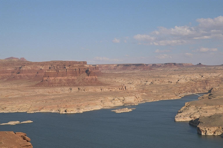
high. Eventually the wash opens up and Lake Powell looms into view. I drive
out to a viewpoint where in one direction I can see the twin marinas of
Bullfrog and Hall's Crossing. Upstream I can see the graceful curves of the
bridge for Rt. 95 across the Colorado, glinting silver in the bright sun. Off
in the distance, all around, I see great stone structures, including several
massive buttes. I wish I could stay to just sit and absorb the 360° view, to
etch it permanently in my brain, a camera cannot possibly do it justice! But,
I must press on.
Back
out on Rt. 95 I head south once more. There is nobody else on the road except
for a Utah road crew. I pass the turnoff to Bullfrog Marina (which I visited
once coming from Capitol Reef - via the Burr Trail). Now I am winding my way
through the impressive canyon of North Wash. The walls are a bright
orange-red and they are towering over me as I slow down to navigate the
curves of the road. The top, composed of what looks like the Wingate
Formation again (or at least a similar sandstone), looks as if there are huge
buildings perched up there, castles in the sky, like Tibetan temples way up
high. Eventually the wash opens up and Lake Powell looms into view. I drive
out to a viewpoint where in one direction I can see the twin marinas of
Bullfrog and Hall's Crossing. Upstream I can see the graceful curves of the
bridge for Rt. 95 across the Colorado, glinting silver in the bright sun. Off
in the distance, all around, I see great stone structures, including several
massive buttes. I wish I could stay to just sit and absorb the 360° view, to
etch it permanently in my brain, a camera cannot possibly do it justice! But,
I must press on.
 On
the other side of the Colorado, the long White Canyon presents glimpses of
its bottom as I drive along. I must be getting higher because the vegetation
is changing from desert scrub to pinyon pine and juniper. Checking my
temperature gauge I see that it's now down to the mid-fifties - so I guess
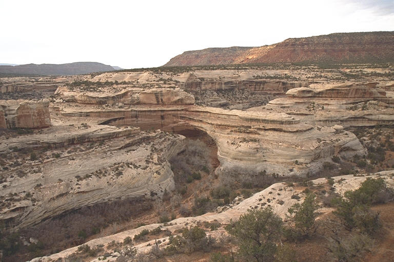
so, huh? I reach Natural Bridges about 3:00 and immediately head for the 8
mile loop road to get my views of the 3 natural bridges: Sipapu, Kachina and
Owachomo. Sipapu is first and it is an impressive sight, 220 feet high and a
span of 268 feet. This is no wimpy little bridge. I take a short trail down,
part of which includes a metal staircase and a wooden ladder, made from
native trees. Cool! Instead of heading all the way to the bottom I elect to
walk out to an overlook about halfway down to get a good look-see and take
pictures. Then it's back upstairs (literally) and on to Kachina.
On
the other side of the Colorado, the long White Canyon presents glimpses of
its bottom as I drive along. I must be getting higher because the vegetation
is changing from desert scrub to pinyon pine and juniper. Checking my
temperature gauge I see that it's now down to the mid-fifties - so I guess
so, huh? I reach Natural Bridges about 3:00 and immediately head for the 8
mile loop road to get my views of the 3 natural bridges: Sipapu, Kachina and
Owachomo. Sipapu is first and it is an impressive sight, 220 feet high and a
span of 268 feet. This is no wimpy little bridge. I take a short trail down,
part of which includes a metal staircase and a wooden ladder, made from
native trees. Cool! Instead of heading all the way to the bottom I elect to
walk out to an overlook about halfway down to get a good look-see and take
pictures. Then it's back upstairs (literally) and on to Kachina.
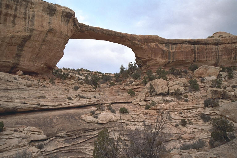
 Kachina
natural bridge is a "young" bridge so it's big and bulky - it
hasn't had as much time to be cut by the stream as the others. It's getting
cold now, that front has finally caught up with me and the sun is behind
clouds, so I just take a quick look and snap. At the third one, Owachomo, I
do decide to hike down so that I get a close-up view and can stand underneath
it (it's only a few tenths of a mile and a short drop in elevation). I
quickly make the easy walk down to be treated to a view of a long, tall,
slim, and graceful span. Very pretty. It spans over a slab of rock which
cascades downward in layers to a small perpendicular stream below. Owachomo
is no longer being cut by the action of water. Instead, it's eroding by the
forces of wind, rain, and frost-action - just like arches. I should note that
all 3 bridges are made up of the crossbedded Cedar Mesa Sandstone, the
predominate formation in the area.
Kachina
natural bridge is a "young" bridge so it's big and bulky - it
hasn't had as much time to be cut by the stream as the others. It's getting
cold now, that front has finally caught up with me and the sun is behind
clouds, so I just take a quick look and snap. At the third one, Owachomo, I
do decide to hike down so that I get a close-up view and can stand underneath
it (it's only a few tenths of a mile and a short drop in elevation). I
quickly make the easy walk down to be treated to a view of a long, tall,
slim, and graceful span. Very pretty. It spans over a slab of rock which
cascades downward in layers to a small perpendicular stream below. Owachomo
is no longer being cut by the action of water. Instead, it's eroding by the
forces of wind, rain, and frost-action - just like arches. I should note that
all 3 bridges are made up of the crossbedded Cedar Mesa Sandstone, the
predominate formation in the area.
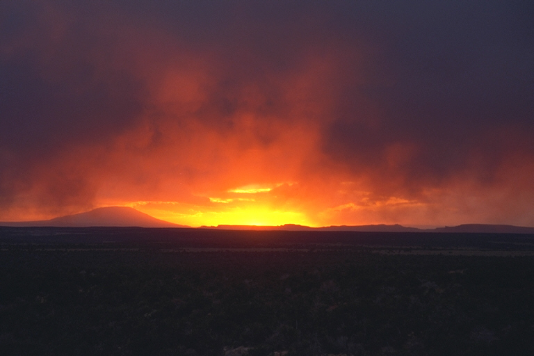
 It's
now cooling rapidly and sunset time. I decide to head for Blanding, about 30
miles away. On the way I look in my rear view mirror and it looks as if the
sky is literally on fire! I almost drive off the road I am so taken by the
sight (and that would not have been a good thing cause there were most
definite drops along the edge of the pavement). I have to stop and record.
It's getting blustery now and my hands start turning numb, but I barely
notice so incredible is the display before me. The sun is setting behind
Navajo Mountain which is sacred to the Navajo Nation and it's as if the
mountain is being consumed by some great cataclysmic conflagration from the
sky. Significant? I don't know. I linger until the cold drives me back into
my truck. Wow!
It's
now cooling rapidly and sunset time. I decide to head for Blanding, about 30
miles away. On the way I look in my rear view mirror and it looks as if the
sky is literally on fire! I almost drive off the road I am so taken by the
sight (and that would not have been a good thing cause there were most
definite drops along the edge of the pavement). I have to stop and record.
It's getting blustery now and my hands start turning numb, but I barely
notice so incredible is the display before me. The sun is setting behind
Navajo Mountain which is sacred to the Navajo Nation and it's as if the
mountain is being consumed by some great cataclysmic conflagration from the
sky. Significant? I don't know. I linger until the cold drives me back into
my truck. Wow!
 I
come into town just as Santa is arriving with his entourage - the Christmas
Parade! All the kids are lined up on either side of the main drag, waving and
cheering, and scrambling to get the candies thrown from the various
personages in the parade. Oh to be young again! (heavy sigh) They didn't
close the road to traffic so initially I am creeping along in the curb lane
with the rest of the parade (and Santa) in the middle lane, wondering what
the hell to do - I just need to find the Best Western. After seeing kids
rushing out into the street to retrieve the candies I decide to cut over a
block to prevent any unfortunate mishaps (thump, thump... oops!). Luckily, I
find the motel 2 blocks later. Tired! While down in the lobby, logged on to
try to find a flight home for Xmas (that's the only place I can get an
Internet connection), I meet and chat briefly with the outside hitter for the
Utah State Girls Volleyball Champion team. Little Blanding (pop. 3200) beat
them all. You go girls!
I
come into town just as Santa is arriving with his entourage - the Christmas
Parade! All the kids are lined up on either side of the main drag, waving and
cheering, and scrambling to get the candies thrown from the various
personages in the parade. Oh to be young again! (heavy sigh) They didn't
close the road to traffic so initially I am creeping along in the curb lane
with the rest of the parade (and Santa) in the middle lane, wondering what
the hell to do - I just need to find the Best Western. After seeing kids
rushing out into the street to retrieve the candies I decide to cut over a
block to prevent any unfortunate mishaps (thump, thump... oops!). Luckily, I
find the motel 2 blocks later. Tired! While down in the lobby, logged on to
try to find a flight home for Xmas (that's the only place I can get an
Internet connection), I meet and chat briefly with the outside hitter for the
Utah State Girls Volleyball Champion team. Little Blanding (pop. 3200) beat
them all. You go girls!
Tomorrow I've got some more spectacular sights to see and record. I plan to head back along 95, then cut south towards the Mokee Dugway and the Valley of the Gods, possibly Monument Valley. I'm hoping the weather continues to be as cooperative as it has been so far - sunny at least, I don't care about the temperature so much. So a good night's rest and an early start - I've got a busy day tomorrow.
See you all soon,
Chris