![]()
![]()
It's a bit chilly outside this morning, low thirties, but when I look outside I see a lot of blue sky up there, some clouds yes, but definitely a lot of blue. Looks like another great day (at least for the start). Let's get going. Driving along 95 towards Natural Bridges, which I did a drive-by on yesterday, I can see the pointy tips of the Comb Ridge Monocline as the road approaches from an angle. From this distance it looks like a series of waves rearing up, getting ready to crash to the floor below. The monocline which extends for about 80 miles was historically a major impediment to east-west travel in the region. The road now curves to the right and heads for a huge cut into the ridge. The top of the ridge towers well over 100 feet above as I drive on through. Dropping down then back up as I cross Comb Wash on the other side and looking back, I see what looks like a huge pink slash across the land - the western side of Comb Ridge. It's obvious how imposing a barrier this must have been. From my vantage point I can see no break, no way to get through or even up and over the steep western face of the ridge. Bummer!
 A
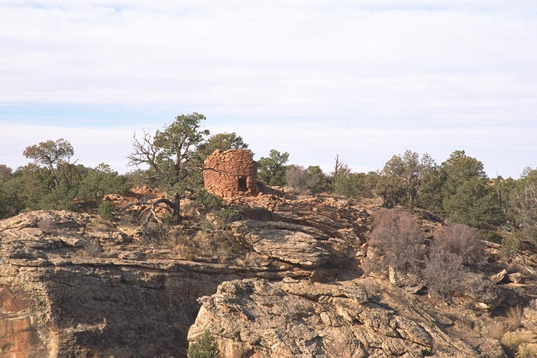
bit farther and I come to a dirt road which leads to the Cave Towers, a group
of Puebloan towers perched high on a cliff. The spur road there is a half
mile of rocky bumps and bounces, not for the low-slung sporty car! At the
end, where the road just kind of runs out I get out and look around,
"Now where do I go?". There are no trail markers or anything that
looks like a trail for that matter. So I head off in the direction that looks
good and after only about a hundred yards or so I come to the site - I
am such a good navigator! I come out to the head of a canyon with the sound
of water tickling my hears. I look over the edge and right below is a pool,
with specks of bright green algae brightening it's dark surfaces. I'm
standing on an overhang and when I move to the side and peer underneath I can
see that the "source" emanates from the rock wall and drips down
into the collecting pool I first spied. From there it flows down over a
series of small drops and into the canyon below. Very pretty.
A
bit farther and I come to a dirt road which leads to the Cave Towers, a group
of Puebloan towers perched high on a cliff. The spur road there is a half
mile of rocky bumps and bounces, not for the low-slung sporty car! At the
end, where the road just kind of runs out I get out and look around,
"Now where do I go?". There are no trail markers or anything that
looks like a trail for that matter. So I head off in the direction that looks
good and after only about a hundred yards or so I come to the site - I
am such a good navigator! I come out to the head of a canyon with the sound
of water tickling my hears. I look over the edge and right below is a pool,
with specks of bright green algae brightening it's dark surfaces. I'm
standing on an overhang and when I move to the side and peer underneath I can
see that the "source" emanates from the rock wall and drips down
into the collecting pool I first spied. From there it flows down over a
series of small drops and into the canyon below. Very pretty.
.jpg) Right
to my left are two tower ruins, one all asunder, just a pile of rocks, the
other with it's walls reduced to a height of about 5 feet. Looking across to
the other side of the canyon, and above a bit, I can see an intact tower with
a portal looking out across to the other side - way cool! Just to the right
of it is another half-fallen down one. I take a few pictures then move along
the left-hand side rim for a better vantage point looking back and to take a
gander out across the valley the canyon comes out on. As I get to the edge
again I am pleasantly surprised to see a cliff dwelling off to my left, just
down from the rim on a ledge. Awesome! So unexpected as I didn't know there
was anything here but the towers. I am delighted! Looking around I can see
why this spot was chosen. It's rather verdant, protected, there's a source of
water, and, as I look out across the valley, the view is just tremendous, the
sounds of nature tickling my ears, the sun warming my chilled body as it
rises towards its low, wintry zenith. It's going to be a great day!
Right
to my left are two tower ruins, one all asunder, just a pile of rocks, the
other with it's walls reduced to a height of about 5 feet. Looking across to
the other side of the canyon, and above a bit, I can see an intact tower with
a portal looking out across to the other side - way cool! Just to the right
of it is another half-fallen down one. I take a few pictures then move along
the left-hand side rim for a better vantage point looking back and to take a
gander out across the valley the canyon comes out on. As I get to the edge
again I am pleasantly surprised to see a cliff dwelling off to my left, just
down from the rim on a ledge. Awesome! So unexpected as I didn't know there
was anything here but the towers. I am delighted! Looking around I can see
why this spot was chosen. It's rather verdant, protected, there's a source of
water, and, as I look out across the valley, the view is just tremendous, the
sounds of nature tickling my ears, the sun warming my chilled body as it
rises towards its low, wintry zenith. It's going to be a great day!
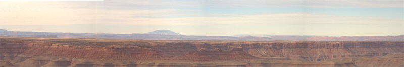
I bounce back to 95 and continue on to the intersection with Rt. 261. Turning south now I barrel down 261 heading towards Muley Point Overlook and the Mokee Dugway. As I drive I pass numerous turnoffs into the Grand Gulch Primitive Area, an area containing many pictographs and petroglyphs with many pre-Anasazi sites scattered within its fifty-two mile length. No wheeled vehicles allowed here, only entry by foot or horseback. Soon I come to the turnoff to Muley Point, an overlook at the end of a 4 mile dirt road. When I reach road's end I am dazzled, no, made breathless, at the sight before me, a miniature version of the Grand Canyon spreading out in front of and below me, the dark, layered rocks in an assortment of mesas separated by serpentine canyons. The spiritually-important Navajo Mtn. looms large to my right, not too distant anymore, while in front and to my left buttes and spires of Valley of the Gods and Monument Valley march toward the horizon. An awesome and spectacular sight. I take another panorama series, but I fear that the moment will not be easily captured by my camera - it's too expansive, too grand. It should be acquired for viewing in an IMAX theatre, or better yet viewed directly in person, a sight worth traveling far to inscribe on your mind's eye. I'd linger longer here, but the wind is whipping by briskly and I am getting cold! Time to go.
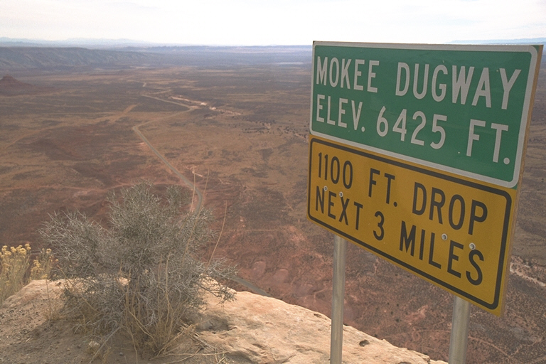 Coming
back onto 261 I turn right and am at the top of the Mokee Dugway which is a
graded gravel road carved out of the side of the plateau I just drove on. It
plunges to the bottom off the valley below via a series of steep and sharp
switchbacks, descending 1100 feet in 3 miles; although the length doesn't
seem anywhere near that long because you're turning so sharply around the
switchbacks while your attention is inexorably drawn to the pageantry of
natural beauty off to your side (first your right, then your left, then your
right, then...). At the bottom of the descent is the turnoff for the 17 mile
dirt road through Valley of the Gods which my appetite for viewing was just
thoroughly whetted for as I twisted my way down. I turn left.
Coming
back onto 261 I turn right and am at the top of the Mokee Dugway which is a
graded gravel road carved out of the side of the plateau I just drove on. It
plunges to the bottom off the valley below via a series of steep and sharp
switchbacks, descending 1100 feet in 3 miles; although the length doesn't
seem anywhere near that long because you're turning so sharply around the
switchbacks while your attention is inexorably drawn to the pageantry of
natural beauty off to your side (first your right, then your left, then your
right, then...). At the bottom of the descent is the turnoff for the 17 mile
dirt road through Valley of the Gods which my appetite for viewing was just
thoroughly whetted for as I twisted my way down. I turn left.
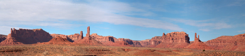
.jpg) Having
an open road ahead of me I step on the gas a bit, but almost immediately come
to a soft, sandy spot in the road with a big old depression that I bounce
hard through, and I mean HARD. Ouch! So I slow down in order to enjoy the
view. Ahead of me are a couple of lonely buttes looking forlornly, yet
regally, down on the surrounding red desert landscape. The road starts rising
slightly as it heads to the north, back towards the plateau I just came off
of. I pass a pair of buttes to my left, whose picture I must stop and take,
and then the road starts through a collection of buttes and long walls eroded
into sections, all up close and personal as I drive through slowly, my eyes
darting from one imposing formation to another. The road winds through the
area with each curve and turn presenting another grand view to me. This is a
photographers dream, the photo opportunities are countless. Any fool with a
throwaway could come out with a collection suitable for framing. Unbelievably
beautiful. As I drive away from the most populated section I spy a good spot
to get a cluster shot so I stop and hike over to capture the sight. As I'm
walking back I happen to glance down and something catches my eye. I bend
down to pick it up and examining it I'm pretty sure I've found a small piece
of petrified wood, colored a deep ruby red to match its surroundings. Bonus!
None of the literature I have on the area mentions anything about petrified
wood. So cool!
Having
an open road ahead of me I step on the gas a bit, but almost immediately come
to a soft, sandy spot in the road with a big old depression that I bounce
hard through, and I mean HARD. Ouch! So I slow down in order to enjoy the
view. Ahead of me are a couple of lonely buttes looking forlornly, yet
regally, down on the surrounding red desert landscape. The road starts rising
slightly as it heads to the north, back towards the plateau I just came off
of. I pass a pair of buttes to my left, whose picture I must stop and take,
and then the road starts through a collection of buttes and long walls eroded
into sections, all up close and personal as I drive through slowly, my eyes
darting from one imposing formation to another. The road winds through the
area with each curve and turn presenting another grand view to me. This is a
photographers dream, the photo opportunities are countless. Any fool with a
throwaway could come out with a collection suitable for framing. Unbelievably
beautiful. As I drive away from the most populated section I spy a good spot
to get a cluster shot so I stop and hike over to capture the sight. As I'm
walking back I happen to glance down and something catches my eye. I bend
down to pick it up and examining it I'm pretty sure I've found a small piece
of petrified wood, colored a deep ruby red to match its surroundings. Bonus!
None of the literature I have on the area mentions anything about petrified
wood. So cool!
Back on the main highway, Rt. 163 I turn
south towards Mexican Hat and the Navajo Reservation. About a mile outside of
the town is the rock formation which gives it its name, an improbably
balanced rock which does look very much like a Mexican sombrero. I don't
stop, but I am compelled to stare at it as I drive by, "How is that big
old top piece staying balanced on that little tiny rock underneath it?"
I guess next time I'll have to take a closer look. The road goes through town
then turns sharply to cross the San Juan River where it takes you into the
lands of the Navajo Reservation. Right at the bend is a cliff-side motel that
practically hangs off the canyon wall here over the river.
I enter the Navajo Reservation and climb up to the plateau. After a few miles the buttes, mittens, towers, etc. loom large in relief as I approach. Already the scale, as compared to Valley of the Gods, is a magnitude more at least. Even from a distance - Wow! The sun has broken away from any cloud cover, and it looks like it's going to be bright and sunny for a while, so I decide to stop at Monument Valley to take some pictures of the monoliths. There is a 17 mile drive you can take, which I've done several times before, but the picture opportunity is just too good to pass up.
.jpg) Right
as you start down is a huge butte off to your left. Huge! It leaps up high
from the valley floor, nothing around except desert scrub. Awesome! I take a
picture and continue on. I go for a mile or so and as the road starts curving
to the right I look up to the sky and see that there are clouds rolling in.
"Where did they come from!?" I hurry towards the next vantage
point. I want to get some more shots before I lose my light. The monuments
look their best with good sunlight shining on them, unfiltered by any but the
thinnest clouds. But, to no avail. The next storm has caught up to me; there
is snow forecast for the Four Corners Area today (where I be at the moment)
and the clouds are filling the sky above. Oh well. It's still awesome,
fantastic, monumental, gargantuan, imposing, grand, just so damned cool!
Though I don't get the pictures I wanted I think I end up getting some pretty
impressive shots nevertheless. We'll have to see how they turn out, and even
though it's my 4th or 5th time through here I leave inspired by the grand
beauty I was fortunate to have just experienced once again. If ever you are
anywhere close to Monument Valley you must stop and take a slow tour to savor
the spectacle present here.
Right
as you start down is a huge butte off to your left. Huge! It leaps up high
from the valley floor, nothing around except desert scrub. Awesome! I take a
picture and continue on. I go for a mile or so and as the road starts curving
to the right I look up to the sky and see that there are clouds rolling in.
"Where did they come from!?" I hurry towards the next vantage
point. I want to get some more shots before I lose my light. The monuments
look their best with good sunlight shining on them, unfiltered by any but the
thinnest clouds. But, to no avail. The next storm has caught up to me; there
is snow forecast for the Four Corners Area today (where I be at the moment)
and the clouds are filling the sky above. Oh well. It's still awesome,
fantastic, monumental, gargantuan, imposing, grand, just so damned cool!
Though I don't get the pictures I wanted I think I end up getting some pretty
impressive shots nevertheless. We'll have to see how they turn out, and even
though it's my 4th or 5th time through here I leave inspired by the grand
beauty I was fortunate to have just experienced once again. If ever you are
anywhere close to Monument Valley you must stop and take a slow tour to savor
the spectacle present here.
.jpg) I
head for home after leaving Monument Valley; the weather is turning towards
the winter norm and I think I've had enough exploring for a while. I pass
through the Navajo "capitol", Kayenta, which as usual has grown
since my last time through. On the other side of Kayenta I drive by the
yellow and black hills, from which the Navajo nation extracts coal, on my
left. On my right, way off in the distance, I can see hills of red and orange
as the land drops down to the Colorado River. It's dark by the time I get off
the reservation and the wind has picked up ferociously; driving through
Flagstaff I am buffeted by gust after gust - both hands on the wheel please!
The rest of the trip is uneventful, except for the part between Needles and
Barstow where once again I am forced to contend with the wiles of the wind as
I blast across the desert, heading for home and a snug bed.
I
head for home after leaving Monument Valley; the weather is turning towards
the winter norm and I think I've had enough exploring for a while. I pass
through the Navajo "capitol", Kayenta, which as usual has grown
since my last time through. On the other side of Kayenta I drive by the
yellow and black hills, from which the Navajo nation extracts coal, on my
left. On my right, way off in the distance, I can see hills of red and orange
as the land drops down to the Colorado River. It's dark by the time I get off
the reservation and the wind has picked up ferociously; driving through
Flagstaff I am buffeted by gust after gust - both hands on the wheel please!
The rest of the trip is uneventful, except for the part between Needles and
Barstow where once again I am forced to contend with the wiles of the wind as
I blast across the desert, heading for home and a snug bed.
Hope you all enjoyed,
Chris