

I don't sleep so well in Wilson's cabin. I think because there is a plastic sheet under the regular one and it causes me to awaken throughout the night, sweating on my backside. Not long after the darkness of night is flushed away by the light of morning, I rise and prepare for the day's treks. Looking at 3 different maps I have to decide which is true. Is there a through route into the park from the east or not? My paper maps say no, there is a break. My electronic one however shows that you can drive in that way (or out the other). Since I've already been along the western portion of Rim Drive, coming in from the east would be non-repeating and "uncharted territory"; my preference always. Going against the odds I decide to try the "East Entrance", so I head south on Rt. 62 towards the Pinnacles of Crater Lake NP.
 Taking a shortcut that cuts straight across to the forest
road I need to get to, I am confronted by a dog just laying in the road. I slow
down 'cause I don't know what he's going to do. "Move you dumb dog!" He is
joined by another from the farmhouse (they're both Australian Shepherds) and
together they "rush" me. I drive carefully past hoping they're not so stupid as
to get caught underneath the truck. No leash laws here!
Not leaving any crow carrion behind, I continue another mile to Sun Mountain Road and turning left onto it head up the hill as it hugs the mountainside on my right. If it wasn't for the trees I would probably have a great view looking west, towards Crater Lake, since the road climbs quickly and a lot. I actually do get glimpses through breaks in the branches, but nothing grand and unobstructed.
A little less than 10 miles along Sun Mountain brings me to the turnoff towards Crater Lake. After another 4 miles I come to... Road's End. Dang it! The sign says that yes this used to be the original East Entrance into the park, but was closed in the '50s due to nonuse (once the other entrances were opened). And that the Forest Service closed it to vehicle traffic in the eighties after a White Pine Beetle infestation in this area. Well, I should have known. But hey. I just added another place to my explorations!
 I turn around and retrace my path, driving carefully past and
once again
being chased by those damned dogs, but blowing right by Wilson and his
cabins without so much as a how do. And after losing only a couple of hours I
arrive back at the park. I stop at the Visitor Center where a nice young lady
(Oh man, do I sound old!) checks the weather up north for me, where I am headed
after today, on the office PC. It looks pretty good!
I head for the eastern portion of Rim Drive, which climbs up and over Vidae Ridge, affording a very nice view back towards Rt. 62 and the valley it traverses on its way to Crater Lake. Hugging the other side of Vidae Ridge, the road takes me to Vidae Falls which tumbles from about halfway up in 2 long cascades. Not impressive, but pretty. Driving along some more I pull over at the first "stop", Sun Notch.
 I walk a short distance up to the rim, passing through a
meadowy area with the occasional tree. The path diverges and I of course take
the shorter, but steeper one up. At the top the path ends against a wooden
railing and as I look out over the rim to the lake below, my breath is taken
from me.
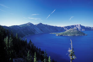
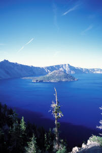
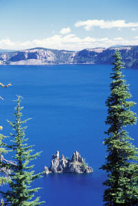
Cobalt blue? No. Sapphire blue? No. Sky Blue? No. Royal? Cerulean? Deep? Icy? Indigo? No, no no! I cannot adequately describe the blue of this lake. It is a blue that wells up from the greatest of depths. (Crater Lake is the deepest lake in the US, 1932'.) A blue which morphs subtly from one shade to another as the sun dances on its surface. A blue that seizes your attention as to render you momentarily senseless. A blue that intoxicates your eyes, so delightfully saturated is the blueness. It is a blue that one must see - and feel - to understand. I am momentarily staggered by the incredible sight. Then I recover.
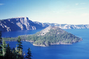
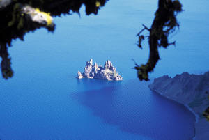
I whip out the camera and proceed to shoot away, hoping that at least 1 will do this scene justice. I see boot prints leading down to a gnarled pine just down the slope a bit. Of course I hop over the rail to go down, and I am rewarded tremendously for my adventurousness by the sight of the Phantom Ship, a small island just offshore from the southeastern edge of the lake. Here, in the shadows, and looking perpendicular to the sun, the waters assume a greenish tint to the deep blues of the lake surrounding the island. The tree at path's end affords some great framing and I compose and shoot away. Then it's back up to the rim and along the top for more breathtaking views and more pictures. Wizard Island now comes into view, fully embraced by the morning sun, and I shoot some more. Looking down I see a little cove and beach with the lakes colors shading from deep to transparent as they become shallower at waters edge. More photos. I am almost exhausted after I am all done, so intense has the experience been.
 Finally, it's back down the hill and I'm on my way along Rim
Drive again. The road continues up and over another ridge buttressing the
caldera, but finally comes up to rim top as it name would imply. Here is the
official viewpoint for Phantom Ship, and the view of it and the whole lake is
impressive, but to tell you the truth, it turns out that Sun Notch is the
absolute best view of the whole day. Here I reassure another visitor that there
is indeed gas available at Mazama so he is able to continue the long way around
Rim Drive.
I next drive to Cloudcap Overlook where Rim Drive reaches its highest elevation of 7960'. At Cloudcap you are smack dead center on the western side of the lake and the sun is basically behind me as it lights the view in front of me. And it does it so well. The wind is blowing strongly today and the lake surface is speckled with whitecaps - tiny looking from my high vantage. Reaching the caldera wall on the west, the wind then blasts up and over the rim - where I stand. It is brisk to say the least so I very quickly retreat. But then I just sit for a while, eating a late breakfast in the shelter of my truck, enjoying the awesome view. The rocks around me are variously colored, adding to the spectrum of visual enjoyment. Also here are some wind-beaten white pines, which manage somehow to overcome the harsh conditions and grab enough succor to grow, their bent, twisted shape attesting to the relentlessness, strength, and direction of the winds.
 Time to go. Coming out I then proceed past Mount Scott, the
highest point in the park (which I and my brother Carl hiked up to 20 years
ago). From here I start dropping down as Rim Drive works its way around the
northern edge of the caldera. I stop one more time on the north side where some
yellow flowers and pinyon pines add a nice foreground to the view of the lake. I
finally reach where I turned around last evening, thereby completing my
circumnavigation of Crater Lake. From here the road leads north out of the park,
but before leaving I stop and take a picture of me by the entrance sign, thanks
to Tom's handy tripod. Thanks Tom!
I take 138 and it takes me through nice stands of fir and pine as it makes a straight eastward shot back to Rt. 97. Back on 97 I head northeast towards my next destination of the day, Newberry NM. I have no idea really what's there, but it is a national monument and it is volcanic so... My planned route is to come in the back way from the south, then up the through the middle, heading north, leading out and up to Bend. Well, let me tell you, "What the hell was I thinking?"
I turn off Rt. 97 onto a paved road that rolls through NF land that is here and there being harvested. No clearcuts but definitely signs of logging activity. I have my GPS working with my mapping software because the charted path first takes one Forest Service road. Then another. Then another. And then another. (You get the picture.) Well, I come to the first turn. This is a red dirt road, but it's in good shape and I head due north towards Newberry. Now I start to see more signs of logging activity. Then I come to the first turn. Except it's not quite where the map says it is. But no biggie. I'll just go to the right a bit and see if I can over a little way down. There are roads and paths all over so I figure something should get me where I want to go.
Sure enough, I take this one road and soon I am back on track. "This Area Being Logged", the signs say. No kidding! I am now driving through an area that has been totally devastated by clear-cutting. I pass idled logging machinery because the "damage" has already been done. The entire area I am driving through has been cut and everything except the debris and detritus has already been hauled off. There are many more roads/paths than showing on the map and if it weren't for my GPS I might actually get lost. But I am able to keep on track as I drive carefully past.
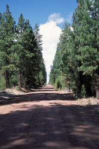 And then I realize the folly of my plan. One never knows how
fast one will be able to travel on a FS road. And if you have 30+ miles of them
to drive on... And if you have wend carefully not only because of the road
conditions, but because you need to avoid chunks of wood and in your path and
branches sticking out into the roadway... This ends up being the trip from hell
(well, almost). I make steady yet very slow progress, all the time trying to
avoid getting scratched up or dinged - sometimes there is barely enough room to
squeeze by without contacting stuff on the sides. The truck isn't even 2 weeks
old!
After driving all afternoon, and not coming out where I wanted, and not seeing any of the monument's "features", I say screw it. I recover with a couple of beers and decide that after gassing up in nearby Bend, I will head up towards Portland so that I can travel up the Columbia River Gorge tomorrow.
So that's what I do. I take 97 out of Bend north to Rt. 26, which takes me first through the Warm Springs Indian Reservation, and then up and over the Cascades, skirting Mt Hood on the south before finally dropping down into the Portland area. Rt. 26 is a very nice drive and the scenery, especially once I am back up in the mountains, revives my driving spirits such that I am once again into the exploring mood by the time I bed down for the evening in Gresham, just east of Portland proper. Unfortunately, the Cascades are overlain with a layer of clouds so I don't get any glimpses of the peaks. Perhaps tomorrow.
Bye!