
![]()
![]()
![]()
 Awakening all refreshed and ready to drive along the Columbia River Gorge, I
hardly tarry getting up and ready to go, and actually get on the road by 11.
(Hey. I'm on vacation!) I easily find my way to the 84 (that would be "...to 84"
for you non-Southern Californians), only a few miles north of the motel. The
midday weather is partly sunny and looks even better as I head east on I-84 and
into the Columbia River Gorge. Mt. Hood, unfortunately, is still hidden from
view by clouds. Too bad, as it's less than 50 miles from here, and if visible,
would be I'm sure an imposing presence considering that though topping out at
only 11,239', is still 11,000' higher than Portland.
Awakening all refreshed and ready to drive along the Columbia River Gorge, I
hardly tarry getting up and ready to go, and actually get on the road by 11.
(Hey. I'm on vacation!) I easily find my way to the 84 (that would be "...to 84"
for you non-Southern Californians), only a few miles north of the motel. The
midday weather is partly sunny and looks even better as I head east on I-84 and
into the Columbia River Gorge. Mt. Hood, unfortunately, is still hidden from
view by clouds. Too bad, as it's less than 50 miles from here, and if visible,
would be I'm sure an imposing presence considering that though topping out at
only 11,239', is still 11,000' higher than Portland.
 Per advice given to me by my neighbor, Jack Ross, I get off
the interstate and onto the Crown Pt. Hwy, which for 20 miles or so meanders
through the gorge the slow, scenic way, passing by - and allowing you to stop
and view - the waterfalls that cascade into the gorge from the south. The road
follows alongside Sandy Creek for a couple of miles before leaving it as the
creek turns south towards Mt. Hood. I see a few fly fisherman working the waters
as I drive by.
Per advice given to me by my neighbor, Jack Ross, I get off
the interstate and onto the Crown Pt. Hwy, which for 20 miles or so meanders
through the gorge the slow, scenic way, passing by - and allowing you to stop
and view - the waterfalls that cascade into the gorge from the south. The road
follows alongside Sandy Creek for a couple of miles before leaving it as the
creek turns south towards Mt. Hood. I see a few fly fisherman working the waters
as I drive by.
Crown Pt. Hwy heads east, initially passing through residential areas. This portion at least is also part of the old Historic Columbia River Parkway. It's nice, but... But then I come to the first scenic overlook - which I almost blow right by - the Portland Women's Forum State Park. Making a U-ey, I go back and into the parking and grab my camera.
Stunning! The view, high above the mighty Columbia River, is eastward into the gorge. The southern side flows down from Mt Hood (still hidden), dropping off suddenly into the gorge. The north side is a series of hills marching higher northward into the state of Washington - up to 6000' only a dozen miles away. All is green; everywhere I look, including the river, which is a pretty greenish-blue. Barge traffic plies the waters below, and vehicles - trains, cars, trucks - wend their way on a narrow ribbon practically hanging above the south riverbank. Miles in front of me, the sun shines through large breaks in the cloud cover, illuminating portions of the river and land, adding some pleasing warmth to the cool greens, grays, and blues elsewhere. It reminds me of the Hudson River Valley. A place that I've seen only in illustrations, mostly in paintings by artists such as Church.
Across the way is a building perched on a promontory that drops dramatically to the river. "Wow! Who gets to live there?" It has a commanding view up and down and across the river (whereas my view west is blocked by the trees behind me). I could live there!
 Back on the road I come upon the "house", which turns out to
be the Visitor Center for Crown Point Park (I guess that would be the name of
the promontory). Unfortunately, it is being constructed/reconstructed and I am
unable to go in for a look see. I do stop though to shoot a few pictures,
including some of some pretty red flowers. The road then drops down quickly from
Crown Point and takes me under a canopy formed by the tall trees on either side
of the road "holding hands" in a light, leafy, green embrace high above me.
Though sheltered from the sun, the way is not dark and gloomy as one might
expect, but light and airy. Cheerful even.
Back on the road I come upon the "house", which turns out to
be the Visitor Center for Crown Point Park (I guess that would be the name of
the promontory). Unfortunately, it is being constructed/reconstructed and I am
unable to go in for a look see. I do stop though to shoot a few pictures,
including some of some pretty red flowers. The road then drops down quickly from
Crown Point and takes me under a canopy formed by the tall trees on either side
of the road "holding hands" in a light, leafy, green embrace high above me.
Though sheltered from the sun, the way is not dark and gloomy as one might
expect, but light and airy. Cheerful even.
Bridal Veil Falls. The first falls to descend from above into the gorge. I pull into the parking area, across which is a small bed and breakfast establishment I notice, and park. I walk up to the sign. "Hmmmm." "...3/4 mile one way "...steep" "Watch for loose gravel" "Ok. I can do this!" Wearing my cargo shorts today, I fill the pockets with camera gear (including the flash) and head on down the path. And, after a few hundred feet, that's just what it does - head down. Hill. Steeply. And it is loose gravel in some spots. "I guess the sign wasn't lying." I march quickly down the path (as I am wont to do), which soon brings a creek into view on it's final rush down to the Columbia. In no time at all I can hear the muted roar of the falls, but not yet see it. Then the path crosses the creek via a neat, little wooden footbridge, and Bridal Veil Falls comes into view.
This is a 2-stepper; I'm guessing maybe 80-100 feet in height, total. It's not gushing but a good stream of waters tumbles down, splashing upon the dark rocks and boulders at the bottom of the falls, in front of which a large, deep looking pool sits, collecting the rush from above before sending it over a very small cascade into the final leg of its journey. A verdant tangle of trees, and ferns, and other green things surrounds the waterworks, whose insistent, yet soothing, crashes and coursings evoke a sense of muted coolness and calmness. A couple, who passed me on the footbridge while I was taking a picture, ask me to take their picture (with their camera), and I happily oblige them. After a few moments I am alone in my enjoyment, so I linger just a tad longer before heading up to the truck again and back onto the road.
 I pass 2 smaller falls, but don't stop to check them out.
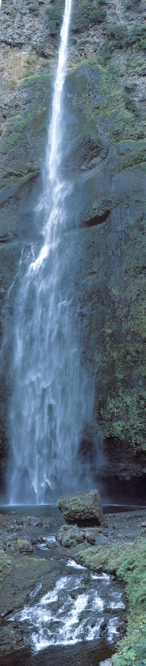
Next is Multnomah Falls, also the name of the nearby town. This is a much bigger
area that is also home to the Columbia River Gorge National Scenic Area Visitor
Center. The tracks for the train run right next to the roadway here and as I
pull in one goes roaring - and I do mean roaring - by. I catch glimpse of the
river through the trees just beyond the tracks as a alight from the truck.
I pass 2 smaller falls, but don't stop to check them out.
Next is Multnomah Falls, also the name of the nearby town. This is a much bigger
area that is also home to the Columbia River Gorge National Scenic Area Visitor
Center. The tracks for the train run right next to the roadway here and as I
pull in one goes roaring - and I do mean roaring - by. I catch glimpse of the
river through the trees just beyond the tracks as a alight from the truck.
There are paved walkways to the left of the Visitor Center that lead up to the falls so I head out amidst the throngs. The falls, visible from the parking area, though partially obscured, soon pop into full view. Ribbons of pearly white water plummet down from the top of the falls in a series of two cascades, the first being much lengthier than the bottom one. Huge boulders at the bottom catapult the spray into a dark, algae-tinted pool, from which the water then tumbles downhill in the creek bed to the Columbia, only a few hundred yards distant. The path winds up the right side in a short series of switchbacks, then crosses over the outfall via a concrete bridge, before proceeding up along the left side to the bottom of the falls.
From below I shoot some picture that include the bridge and clusters of the admiring crowd. I then proceed up the path to the bridge where I take some "no people" shots, including a set for a vertical panoramas (I hope it comes out). Again the falls are not sending tremendous quantities of water over the precipice - it's late summer after all - but a good amount comes down, creating a "gentle" roaring sound; not so loud as to interfere with normal conversations. The sun is playing hide-and-seek with the breaking cloud cover and when shining through, dramatically enhances the already great view of the falls and adjoining foliage.
 I make a quick tour of the Visitor Center where I ponder
buying some national forest maps, but I resist the temptation this time and soon
head back to the truck and to the interstate. Next stop: Hood River.
I make a quick tour of the Visitor Center where I ponder
buying some national forest maps, but I resist the temptation this time and soon
head back to the truck and to the interstate. Next stop: Hood River.
I-84 runs close to the river here and I'm soon approaching the first dam on my route today: Bonneville Dam & Locks. Nothing special about it so I just take some quick, non-accident causing glances as I drive by. The wind is picking up just a bit - blowing upstream - and the river is full of whitecaps. I pass quite a few large barges heading down to Portland for further transshipment, loaded with who knows what.
to be continued...
 |
 |