![]()
![]()
![]()
Well, now I know why the vehicle traffic sounded so loud. The
“%@*!#” window was open! I realized this when I awoke at 6 am (unheard of) and
took a peek outside. Oh well. I thought about getting up for good at that point
but… I eventually rousted my self about 7:30, took my time getting myself all
cleaned up and ready to go, and got on the road just before 9:30.
 The sky is a clear, crisp blue and the sun rapidly warming the countryside as I
leave Twisp. Eleven miles up the road is Winthrop, a charming little tourist
haven with old-style buildings housing an assortment of gift, craft, souvenir
shops as well as an abundance of eating and drinking establishments. (Espresso
anyone?) I stop at the FS station to get a few maps (I don’t know why as I seem
to never use the darn things, but it’s what I do), and then amble over to a
locally grown fruit stand where I purchase an assortment of plums, nectarines,
apples and plums. While I wait for my produce to be tallied and bagged, I listen
to the softball game being played across the road. Those guys are having too
much fun over there! “Don’t worry. He’ll stop at 2nd; otherwise he’ll have a
heart attack” “Go! No stay! No go!” “Hey! Don’t get run over by a truck!”, as
one fellow chases an overthrown ball which is bouncing down the road.
The sky is a clear, crisp blue and the sun rapidly warming the countryside as I
leave Twisp. Eleven miles up the road is Winthrop, a charming little tourist
haven with old-style buildings housing an assortment of gift, craft, souvenir
shops as well as an abundance of eating and drinking establishments. (Espresso
anyone?) I stop at the FS station to get a few maps (I don’t know why as I seem
to never use the darn things, but it’s what I do), and then amble over to a
locally grown fruit stand where I purchase an assortment of plums, nectarines,
apples and plums. While I wait for my produce to be tallied and bagged, I listen
to the softball game being played across the road. Those guys are having too
much fun over there! “Don’t worry. He’ll stop at 2nd; otherwise he’ll have a
heart attack” “Go! No stay! No go!” “Hey! Don’t get run over by a truck!”, as
one fellow chases an overthrown ball which is bouncing down the road.
 With fresh fruits bagged (and in a handy-dandy box), I set out once again.
Leaving Winthrop, the land roadsides are once again bordered by farms, most of
which seem to be fruit growing acreages. I am now driving up the Methow Valley,
which is defined by ever-increasing heights of charcoal-gray rocks with
outcroppings and streaks of ocher, lighter grays and pale greens, the Methow
River meandering from side-to-side as it trends southeast towards the Columbia
River. Once past the little resort of Mazama the valley narrows and the trees
once again grow close to the road as it assumes a serpentine character, gaining
increasing amounts of elevation with each twist and turn. As I drive I notice
bushes draped with bunches of what looks like blueberries as they flash past my
speeding (but legally so) vehicle. I pull over after a bit to get closer look
see. Well, I don’t think they’re blueberries after all, as they’re much smaller
and I believe that blueberries grow in a boggy environment, but they may very
well be a relative. Nevertheless, interesting and very cool.
With fresh fruits bagged (and in a handy-dandy box), I set out once again.
Leaving Winthrop, the land roadsides are once again bordered by farms, most of
which seem to be fruit growing acreages. I am now driving up the Methow Valley,
which is defined by ever-increasing heights of charcoal-gray rocks with
outcroppings and streaks of ocher, lighter grays and pale greens, the Methow
River meandering from side-to-side as it trends southeast towards the Columbia
River. Once past the little resort of Mazama the valley narrows and the trees
once again grow close to the road as it assumes a serpentine character, gaining
increasing amounts of elevation with each twist and turn. As I drive I notice
bushes draped with bunches of what looks like blueberries as they flash past my
speeding (but legally so) vehicle. I pull over after a bit to get closer look
see. Well, I don’t think they’re blueberries after all, as they’re much smaller
and I believe that blueberries grow in a boggy environment, but they may very
well be a relative. Nevertheless, interesting and very cool.
The road is rife with riders, pumping furiously up the long, long upgrade with
few stretches of flat to allow recovery, however temporary, of oxygen-starved,
burning muscles (well, mine would be). Their efforts remind me that there is no
honor in my own bike’s extensive dust collection and that I really need to get
back to riding. It’s great exercise (which I badly need) and I spent enough on
the fancy thing. Things to do. The tops of the valley have now assumed a more
rugged and jagged appearance, portents of things to come I should think.
Beautifully so too. I look forward to the rest of the drive through the national
forest and North Cascades NP itself. Onward!
 After a couple of sharp switchbacks, the road crests at Washington Pass (elev.
5477) and I stop at the scenic overlook area to, well, overlook. I hike the
short trail and come out upon a precipitous drop off below which spreads before
me the valley from which I just came. Gorgeous! I snap off a few and, while
doing so, am joined in my aerie by the sound and antics of one of the ubiquitous
grasshoppers drunkenly click-clacking through the air. Just it and I though.
Solitude. Peacefulness. Time to move on.
After a couple of sharp switchbacks, the road crests at Washington Pass (elev.
5477) and I stop at the scenic overlook area to, well, overlook. I hike the
short trail and come out upon a precipitous drop off below which spreads before
me the valley from which I just came. Gorgeous! I snap off a few and, while
doing so, am joined in my aerie by the sound and antics of one of the ubiquitous
grasshoppers drunkenly click-clacking through the air. Just it and I though.
Solitude. Peacefulness. Time to move on.
Down from Washington Pass, then up and over Rainy pass I go. Past Rainy pass the
roadway hugs the side of the cliffs as it follows Granite Creek down towards
Ross Lake. High above I can see lingering pieces of the mighty snowfall that
descends upon this area each winter (this portion of Route 20 is closed then).
Far in front appears Crater Peak which looks to be the remnants of a volcano
that blew its top eons ago leaving only two jagged remnants of its cone.
At Ross Lake there are a couple of huge arch dams holding back the waters for
electrical power generation. The lower of the 2 lakes, Diablo, is a stunning
light green color, due to the minerals washed down from the surrounding hills
and peaks, reminiscent of the waters found in Glacier NP in Montana. Absolutely
beautiful! I finish yet another roll (11 and counting) here, I am so taken by
the scenery.
From Diablo Lake (which is actually in the Ross Lake National Recreation Area),
the road now hugs tightly to the shore of yet another impoundment, long and
skinny Gorge Lake which soon ends at Gorge Dam. From there it’s just a few more
miles into the settlement of Newhalem in which reside the park headquarters and
visitors center. Below Gorge Dam, the Skagit River flows in its natural channel
once again, and the walls of the valley tower high above it as I head into
Newhalem, festooned with abundant growths due to the weeps and springs emanating
from their rocky surfaces, an example of how North Cascades is defined by water,
in all its many forms: ice, sleet, snow, liquid, mist, dew, fog. Without water
there would be no North Cascades NP.

I see the “feature” movie in the visitor center, which is quite different from
what you would expect. This is much more of an artistic, inspirational film as
compared to your regular park fare. Quite well done and I recommend it if you
are fortunate enough to pass this way yourself. I grab the free guide and
purchase a hiking guide for a buck. Looking briefly at my pamphlets I am just a
touch dismayed that I did not have this information sooner as there are a couple
of things to do and see on the way in (from the east) that, had I been aware of,
I probably would have taken the time to do them. Next time.
 I take a quick spin through the campground across the road – mostly for groups –
and come away wishing that I could spend a night or few there. It’s hard up
against Goodell Creek and is literally carved out of the forest, which is
populated by huge specimens of trees, draped in blankets of the bright green
gauze of mosses, with abundant deciduous trees and bushes and plants of all
sorts. Wonderful, especially the setups for groups. I highly recommend it for
the locals. (Norm & Janis? Christine?)
I take a quick spin through the campground across the road – mostly for groups –
and come away wishing that I could spend a night or few there. It’s hard up
against Goodell Creek and is literally carved out of the forest, which is
populated by huge specimens of trees, draped in blankets of the bright green
gauze of mosses, with abundant deciduous trees and bushes and plants of all
sorts. Wonderful, especially the setups for groups. I highly recommend it for
the locals. (Norm & Janis? Christine?)
Road’s end. How cool is that! At the spur of the moment I decide to take one
last “exploration” before heading out and down to Seattle. Just outside the park
is Cascade River Road, which goes up along the Cascade River (and its North
Fork) for 23 miles, where it dead ends. How special to reach the end of a road.
I think it’s important that we at least occasionally go and drive to the end of a road,
to get away from life’s little miseries and reconnect ourselves with the natural
beauty and wilderness that is sometimes only obtainable - at the end of
the road.
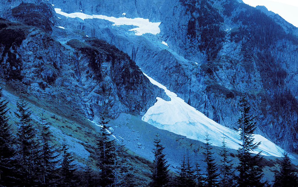
So now I am in a bowl formed by the surrounding peaks and from here the more adventurous can set out up the trail to various wonderful alpine destinations. Not for me today though. It's already past 4 and it's a long drive back down (part of that, the first few miles, being single lane road). It seems for picture taking sake I have arrived to late as only the midday sun is able to reach these craggy edifices festooned with meadows and, higher up, small glaciers. Oh well. I shoot off a few pics nevertheless, but record in my mind's eye the best ones. I finally eat lunch, just enjoying the cool, crisp, alpine air and the view back down the valley. Soon enough though it's time to head back down and on to Seattle where I have friends to see.
Later!