![]()
![]()
![]()
I wake early, about 7am, and get up to check the weather. Peering out the bedroom window I see that it must have been a pretty nice sunrise; the clouds to the east are tinged with a soft pink color. But the east, which is mostly clear, is not the important direction. Looking the opposite direction I see a sheet of clouds advancing, slowly, my way. "Looks like that storm front is almost here." I probably should get up and get going now before the clouds roll in and diminish picture taking opportunities, but... "It's only 7 o'clock!" So I hop back into the comforting embrace of the bed covers and return to the land of warm slumber.
I finally roust myself at about 9:30. After getting ready I peer out the window to check the weather again. Small patches of blue sky with hazy sunshine. Not too bad. Obviously, the storm has not yet reached this far and though the sun is filtered by the clouds, at present it's still fairly bright. I gather my gear and pack the truck. Into the cooler goes the requisite sodas and a couple of Coronas. Feeling lazy, I pack a lunch of Pringles and jerky; I don't eat much during the day anyway. I'm on the road, heading east on Rt. 12 by 10:30. Not too bad don't you think?
 Rt. 12 drops down from the turnoff to Bryce canyon into the Bryce Valley where the
very, very, very small towns of Tropic, Cannonville,
and Henrieville are. On the way down the road skirts the northern edge of the Bryce amphitheatre, affording a nice farewell view of the park as one heads towards
other adventures. In Tropic, the first town encountered, are a few small motels and bed & breakfasts. It takes about 30 seconds to drive through it.
Two miles later I pass through Cannonville where the turnoff for Kodachrome Basin, Grosvenor Arch, Cottonwood Wash, The Cockscomb, Bull Valley
Gulch, Willis Creek/Slot Canyon, etc is. All great places to visit, but not today.
Rt. 12 drops down from the turnoff to Bryce canyon into the Bryce Valley where the
very, very, very small towns of Tropic, Cannonville,
and Henrieville are. On the way down the road skirts the northern edge of the Bryce amphitheatre, affording a nice farewell view of the park as one heads towards
other adventures. In Tropic, the first town encountered, are a few small motels and bed & breakfasts. It takes about 30 seconds to drive through it.
Two miles later I pass through Cannonville where the turnoff for Kodachrome Basin, Grosvenor Arch, Cottonwood Wash, The Cockscomb, Bull Valley
Gulch, Willis Creek/Slot Canyon, etc is. All great places to visit, but not today.
After another couple of miles I pass through Henrieville, the last settlement until Escalante, another 30 miles away. From there the road starts to rise gradually, and soon I start catching glimpses of Powell Point. Then the road jumps quickly up to a plateau where a scenic view point is so I stop. The view is of Powell Point, resplendent in white and pink, surrounded by the diminutive cohorts of the Gray Hills, cloaked in the more subdued shades of charcoal gray and chocolate brown. I shoot a few and admire, sharing the view with a couple of young ladies who alight from a Mustang bearing Washington State license plates. The weather seems to be holding up - its mostly sunny and the clouds in the sky are thin and non-stormy looking. Cool.
Moving on I quickly come to a dirt road signed, "Canaan Mtn. ->". Now, over the years I've passed this sign more times than I can count as I headed towards Escalante and beyond - most sights away from Bryce Canyon are out this way - and every time I've thought, "I wonder what's up Canaan Mtn.?" and, "I gotta check that out sometime." But every time I had another destination in mind so I just drove on by, "Maybe next time." Well, "next time" is here. I am going to see what's up the road to Canaan Mtn. My destination IS Canaan Mtn. Yayyy! Someplace new. Time to go exploring!
 I turn onto the dirt road which heads up into the hills. The road is in pretty good shape - no washboard or anything - so that's
nice. A little bit of elevation gain and I'm roll down the window to breathe in the clean, fresh scent of the pine tree-filled area I now find myself
in. Off to my left a few wild turkeys go strutting up the hill. The road takes a sharp bend to the left, but where it does a faint track goes off uphill to the right. I
go right of course. Carefully, I
wind my way through the narrow tree gaps and under the low hanging branches to a clearing where the spur ends. Getting out of the truck I walk over to
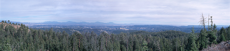
the edge of the mountainside where I get a great view back towards Powell Point, Bryce Canyon, and beyond!. How nice! I get out the tripod so I can take a
candid of myself by the truck: Two! Explorers.
I turn onto the dirt road which heads up into the hills. The road is in pretty good shape - no washboard or anything - so that's
nice. A little bit of elevation gain and I'm roll down the window to breathe in the clean, fresh scent of the pine tree-filled area I now find myself
in. Off to my left a few wild turkeys go strutting up the hill. The road takes a sharp bend to the left, but where it does a faint track goes off uphill to the right. I
go right of course. Carefully, I
wind my way through the narrow tree gaps and under the low hanging branches to a clearing where the spur ends. Getting out of the truck I walk over to
the edge of the mountainside where I get a great view back towards Powell Point, Bryce Canyon, and beyond!. How nice! I get out the tripod so I can take a
candid of myself by the truck: Two! Explorers.
Back on Canaan Mtn Road, I drive over some areas covered by a thin veil of snow; not enough to cause any concern though (not that I would be too concerned 'cause after all, I do have 4WD). I drive by another spur, S20, which isn't even on my map. It seems to head up higher, whereas I'm already starting to loop around and head back down so... of course I stop, reverse, and get onto S20 to see where it goes!
 It goes up the mountain. Rounding a curve, I spot a grove of aspen trees, bereft of their leaves this late in the year. Their
thin, white trunks always seem to stand out as a nice counterpoint to the browns and greens of the forest so I stop the truck to take a few. The fact that I'm taking pictures of aspens is indicative of the increased elevation I've reached (aspens aren't usually found below 8000'). Back
in the truck, I bounce my way along - this road is a bit rougher than the "main" one - passing through an area has seen the loggers saw, but minimally so as
to not detract too much from the "wilderness experience". Then I come upon a very steep, narrow section, mostly covered with a thin layer of
snow (north exposure).
Just to be sure, I lock it into 4WD and barrel up, keeping my momentum so as to not start slipping or sliding. No problem!
It goes up the mountain. Rounding a curve, I spot a grove of aspen trees, bereft of their leaves this late in the year. Their
thin, white trunks always seem to stand out as a nice counterpoint to the browns and greens of the forest so I stop the truck to take a few. The fact that I'm taking pictures of aspens is indicative of the increased elevation I've reached (aspens aren't usually found below 8000'). Back
in the truck, I bounce my way along - this road is a bit rougher than the "main" one - passing through an area has seen the loggers saw, but minimally so as
to not detract too much from the "wilderness experience". Then I come upon a very steep, narrow section, mostly covered with a thin layer of
snow (north exposure).
Just to be sure, I lock it into 4WD and barrel up, keeping my momentum so as to not start slipping or sliding. No problem!
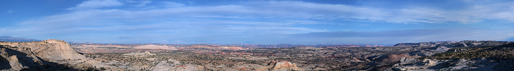
At the top of the snowy stretch I come to a section which has been totally harvested, decimated even, but because of that, the view to the east is unobstructed, and... Wow! The Aquarius Plateau, Boulder Mountain, The Hogsback, the Henry Mountains, the Circle Cliffs, Kaiparowitz Plateau, Smoky Mountain, Navajo Mountain. All are visible in a grand sweep from north to south! A spectacular view at road's end! Grand as the view is I suspect it would be even more so if the sun was not veiled by the thin clouds slowly encroaching from the northwest, and if it was later in the day - say mid-afternoon - when the sun's rays would be shining more obliquely and with the warm colors it saves for the latter part of the day. Nevertheless, I feel rewarded for venturing off the beaten path and taking the one not so. Well worth the effort, and the wait.
Heading back down, I shift into low to traverse the snow, and soon am back on Canaan Mtn. Road. Looking at the map I see that I can either head back down the way I came up, or continue on and loop around to Rt. 12 a mile past where I turned off. Well, as I hate to backtrack, I decide to keep straight. In no time at all though I start to wonder about my decision as the road becomes narrower and fainter, and obviously less-traveled. Oh well. The going is slow, mostly because of the humps in the road - for drainage purposes I suppose. I have to go over them very slowly, and some of the higher ones cause the truck to scrape along the bottom.
 I pick my way carefully downhill, avoiding as much as possible the close growing trees and shrubs, though not worrying about the
stuff growing in the middle of the track which I instead "mow" down. I am of course tracking my progress on the PC with my GPS, and so far I am right
on track. But then the road comes to a creek bed, Willow Creek, and... "Where's the crossing on the other side?" I look closer at the map and see that
the road and the creek become one for a while. "Oh. I see." Well, not to worry because the creek is more sand and rocks than water - only a thin
ribbon meanders down the creek bed - and I'm more "feet dry" than "feet wet". And right where my "map" says I should leave the creek I heave
back up onto dry land. Having dropped back down quite a bit and with the sun now shining unobscured by clouds the air has warmed to 53°, and I stop for
a few minutes to bask in the pleasantness of the day.
I pick my way carefully downhill, avoiding as much as possible the close growing trees and shrubs, though not worrying about the
stuff growing in the middle of the track which I instead "mow" down. I am of course tracking my progress on the PC with my GPS, and so far I am right
on track. But then the road comes to a creek bed, Willow Creek, and... "Where's the crossing on the other side?" I look closer at the map and see that
the road and the creek become one for a while. "Oh. I see." Well, not to worry because the creek is more sand and rocks than water - only a thin
ribbon meanders down the creek bed - and I'm more "feet dry" than "feet wet". And right where my "map" says I should leave the creek I heave
back up onto dry land. Having dropped back down quite a bit and with the sun now shining unobscured by clouds the air has warmed to 53°, and I stop for
a few minutes to bask in the pleasantness of the day.
A hundred yards ahead is a narrow gate and that's where I now head. However, arriving there I see that I must traverse a deep ditch, at an angle, in order to continue. Examining it with a studied eye I calculate that it's quite passable, though only with care and caution. I shift into low-low and proceed. Down I go, then up the other side. Climbing up the far side first, the right front wheel bites only air - 3 wheels! Then the left front crests and I'm balancing on just 2 wheels. Woohoo! What a ride! Punching the gas, the wheels slipping before grabbing hold, I power up and over the other side onto solid - and flat - ground, and I'm on my way again. The road now is increasingly hard to see; the vegetation hardly breaks for the track. But according to the GPS I'm right on so I continue. It's been a slow, tough haul getting down here and I wonder what lies ahead. I will soon find out.
 Paralleling a dry creek bed, I
can see it curving around in front of me and... "Whoa!" I slam on the brakes and skid to a stop because,
well because there is nowhere else to go. The creek bed crosses in front of me then curves right to head down the hill - where the road I was
traveling on should be going. But I see no track or path. I get out to take a look see. I walk along the soft, eroded sides of the creek bed on the
left and, examining it, I can see that this is where the road used to be. It has been washed away. I walk around some trying to find another way to
proceed. Perhaps if I cross over upstream, then... No. No place for that. Maybe I can skirt around on the left, up the hill then back down... I walk
up to check.
Paralleling a dry creek bed, I
can see it curving around in front of me and... "Whoa!" I slam on the brakes and skid to a stop because,
well because there is nowhere else to go. The creek bed crosses in front of me then curves right to head down the hill - where the road I was
traveling on should be going. But I see no track or path. I get out to take a look see. I walk along the soft, eroded sides of the creek bed on the
left and, examining it, I can see that this is where the road used to be. It has been washed away. I walk around some trying to find another way to
proceed. Perhaps if I cross over upstream, then... No. No place for that. Maybe I can skirt around on the left, up the hill then back down... I walk
up to check.
No way in hell! I'm stuck. I am not going forward - not today anyway. All that slow picking of my way down, over those road humps, the brush scratches... Oh well. What are you going to do? I back up to a spot where I can turn around and head back the way I came. The ditch is traversed with nary a hitch and soon I am splashing my way up Willow Creek. The turnoff up the mountain soon comes into view and I power up the creek bank, slipping a bit before the tires bite, propelling me upwards towards Canaan Mtn. Road. Driving over the humps from the other direction is easier - and quicker - though more slippery; I suppose 'cause I'm driving uphill instead of "coasting" downhill. Nonetheless, I make very good process, and rather quickly am back on Canaan Mtn. Road. The sky is blue and the sun strong, and I find a nice clearing to pull over to savor a Corona, after my "ordeal".
Then back down to Rt. 12 and towards Escalante. The cliffs on the left rise high above me in shades of golden yellow. I stop at a view point where an informative sign points out signs of the ancient Fremont Indians across the road and above. I enter Escalante a little before 4 and, as the sun sets about 5, I decide to head to the Hogsback Overlook about 5 miles on the other side. I get there and as always am delighted by the view - surely one of my most favorite of all the ones that I've seen in my explorations and travels. I never tire of it. This is a perfect candidate for a panorama series so I grab the trusty tripod from the truck and set up the camera. I shoot a couple of series and decide to call it a day. I head back towards Bryce and the Bryce Canyon Pines Motel where I know a warm, cozy fire is just waiting to be built. I hope that the sun will break free of the clouds as I pass Powell Point - it's especially pretty when lit by the setting sun - but that is not to be today. I arrive back at the cottage as twilight descends upon the area, and in no time I have a fire roaring in the fireplace, my feet up, my hand clenching a frosty Corona, reflecting on a day well spent. I'll worry about dinner later as I relax and reflect.
A day well spent indeed!