![]()
![]()
![]()
 So
here I am rocketing through a wind and water-sculpted, multi-hued landscape
(Mark’s a fast driver), on my way to Hell’s Backbone. The sun is nearing
its peak on this balmy (for Bryce) Thanksgiving Day (low 40’s), which at
this time of year is not high at all. The deep blueness above is slowly
softening to a grayish white as large masses of flat clouds fill up the sky.
Could there be a storm approaching? The road we’re on, Scenic Byway Rt. 12
is winding its way to Escalante, a nearby Mormon pioneer town that has lent
its name to the area surrounding it (Grand Staircase-Escalante National
Monument, Escalante River, Escalante Canyon). The rocks around us are various
shades of yellow and white. Today, Thanksgiving Day, Mark and I are going to
take a big loop tour of some of the special scenery available here, starting
and ending in Escalante. From Escalante we’ll be heading out along the
Hogsback, past Calf Creek Falls to the turnoff to Hell’s Backbone. Hell's
Backbone travels along a ridge with dramatic and precipitous drop-offs on
either side. At the Hell's Backbone Bridge the ridge narrows to the bridge's
width and the sense of vertigo can be overwhelming. It then winds it’s way
up into the Dixie Forest skirting the Box Hollow Death Wilderness before
dropping quickly back to Escalante. The last (and only time) I was on this
road a storm front was just passing through so I encountered dense fog at the
“crucial” juncture, which turned into a veil of snow as I went higher.
Let’s hope I have better luck this time.
So
here I am rocketing through a wind and water-sculpted, multi-hued landscape
(Mark’s a fast driver), on my way to Hell’s Backbone. The sun is nearing
its peak on this balmy (for Bryce) Thanksgiving Day (low 40’s), which at
this time of year is not high at all. The deep blueness above is slowly
softening to a grayish white as large masses of flat clouds fill up the sky.
Could there be a storm approaching? The road we’re on, Scenic Byway Rt. 12
is winding its way to Escalante, a nearby Mormon pioneer town that has lent
its name to the area surrounding it (Grand Staircase-Escalante National
Monument, Escalante River, Escalante Canyon). The rocks around us are various
shades of yellow and white. Today, Thanksgiving Day, Mark and I are going to
take a big loop tour of some of the special scenery available here, starting
and ending in Escalante. From Escalante we’ll be heading out along the
Hogsback, past Calf Creek Falls to the turnoff to Hell’s Backbone. Hell's
Backbone travels along a ridge with dramatic and precipitous drop-offs on
either side. At the Hell's Backbone Bridge the ridge narrows to the bridge's
width and the sense of vertigo can be overwhelming. It then winds it’s way
up into the Dixie Forest skirting the Box Hollow Death Wilderness before
dropping quickly back to Escalante. The last (and only time) I was on this
road a storm front was just passing through so I encountered dense fog at the
“crucial” juncture, which turned into a veil of snow as I went higher.
Let’s hope I have better luck this time.
 We
gas up in Escalante (Hot tip - even if a station is closed you might still be
able to get gas if it has a pay-by-card thingy. Lucky for us!). We head out
of town, past the turnoff to Hole-In-the-Rock and head north. After a few
miles and rounding a very sharp curve ("Whoa there Markie!") we
come upon the Hogsback stretching away from us to the north. The
Hogsback is a section of Rt. 12 that dips and dives, swoops and swirls, curves
and curls among the grayish-white local formations that are mostly rounded
globs of rock, as if from an ancient sand dune field. We drop down quickly
(12% grade) and proceed to find ourselves amongst them. After a few miles we
round another sharp curve and are presented with a view of the brick red
rocks of the canyon cut by the Escalante River. Another quick descent brings
us down to the river’s level, which is demarcated by the towering, now
leafless, cottonwoods along its banks. Another quick curve and we’re
surrounded by the red rocks as we start winding our way up again, across Calf
Creek and past the trail to Calf Creek Falls. We quickly regain our lost
elevation and the original colors at the start. Off to the west (left)
we can look down into the canyon cut by Calf Creek, spying the trail to the
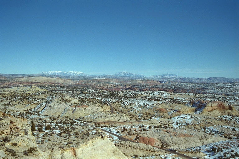
falls at various times as we twist and turn ever upward. To
the east stretch rows of canyons waiting to be explored. Soon we top out and
the road gets even more interesting as on either side it quickly drops off to
the bottoms below; we are riding along the top of a narrow ridge. It was this
part that especially imprinted itself when my brother Carl and I first
traveled through this area 18 years ago. Mark is impressed as it is his first
time here. As for myself, even after all the times I’ve been along this
section of road, I am still impressed and am enjoying the ride and scenery
immensely.
We
gas up in Escalante (Hot tip - even if a station is closed you might still be
able to get gas if it has a pay-by-card thingy. Lucky for us!). We head out
of town, past the turnoff to Hole-In-the-Rock and head north. After a few
miles and rounding a very sharp curve ("Whoa there Markie!") we
come upon the Hogsback stretching away from us to the north. The
Hogsback is a section of Rt. 12 that dips and dives, swoops and swirls, curves
and curls among the grayish-white local formations that are mostly rounded
globs of rock, as if from an ancient sand dune field. We drop down quickly
(12% grade) and proceed to find ourselves amongst them. After a few miles we
round another sharp curve and are presented with a view of the brick red
rocks of the canyon cut by the Escalante River. Another quick descent brings
us down to the river’s level, which is demarcated by the towering, now
leafless, cottonwoods along its banks. Another quick curve and we’re
surrounded by the red rocks as we start winding our way up again, across Calf
Creek and past the trail to Calf Creek Falls. We quickly regain our lost
elevation and the original colors at the start. Off to the west (left)
we can look down into the canyon cut by Calf Creek, spying the trail to the
falls at various times as we twist and turn ever upward. To
the east stretch rows of canyons waiting to be explored. Soon we top out and
the road gets even more interesting as on either side it quickly drops off to
the bottoms below; we are riding along the top of a narrow ridge. It was this
part that especially imprinted itself when my brother Carl and I first
traveled through this area 18 years ago. Mark is impressed as it is his first
time here. As for myself, even after all the times I’ve been along this
section of road, I am still impressed and am enjoying the ride and scenery
immensely.
.jpg) Just
before it’s time to drop down into the town of Boulder we see the turn off
for Hell’s Backbone so off we go. Now we’re on
gravel, which of course is no problem except for the washboard portions, of
which there are plenty, that are also on curves. No traction baby!
E-ticket! The road curves its way down a bit and we glide (slide?) past a few
small ranches whose notable feature is the various types of fences marking
their boundaries built from local, rough-hewn trees. Like in the “old”
days I suppose. As we get a little farther in, the road
smoothes out a bit and even straightens a touch – for
a while anyway – and we soon spy a small grove of aspens, alone among the
pines and firs surrounding them. Behind them, in the direction we are
heading, we can see the rose-splattered, tawny yellow rocks near the bridge.
Picture time!
Just
before it’s time to drop down into the town of Boulder we see the turn off
for Hell’s Backbone so off we go. Now we’re on
gravel, which of course is no problem except for the washboard portions, of
which there are plenty, that are also on curves. No traction baby!
E-ticket! The road curves its way down a bit and we glide (slide?) past a few
small ranches whose notable feature is the various types of fences marking
their boundaries built from local, rough-hewn trees. Like in the “old”
days I suppose. As we get a little farther in, the road
smoothes out a bit and even straightens a touch – for
a while anyway – and we soon spy a small grove of aspens, alone among the
pines and firs surrounding them. Behind them, in the direction we are
heading, we can see the rose-splattered, tawny yellow rocks near the bridge.
Picture time!
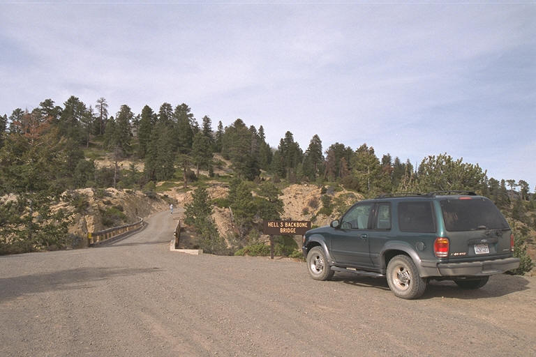 On
our way once more we start gaining elevation again and soon come upon a very
narrow, wooden bridge spanning the short gap in front of us – the Hell’s
Backbone Bridge. “You mean we’re gonna drive over that little,
insubstantial thing?” While right below the drop isn’t so much, just
beyond the rocks quickly fall away to prodigious
depths. Don’t take any running leaps - as Mark said,
you might starve to death before you hit bottom. The rocks here are yellows
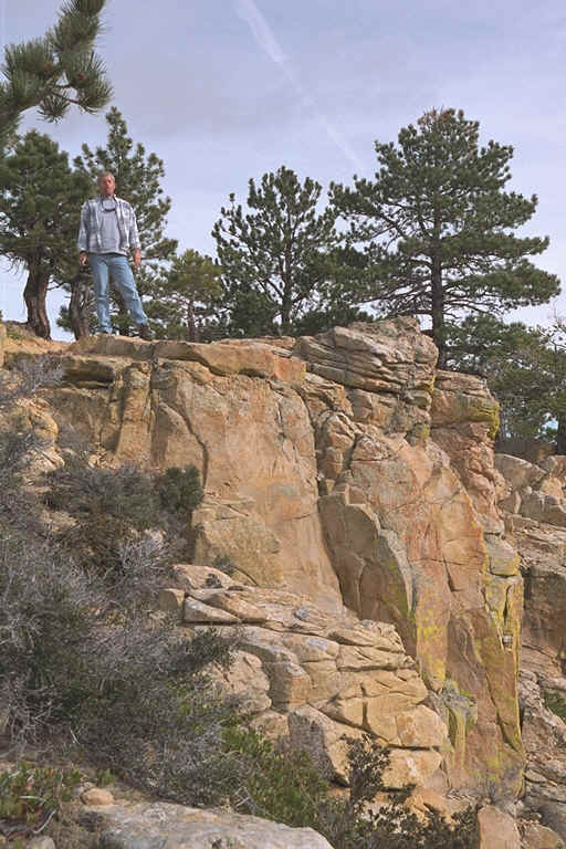
and tans and reds and oranges and very pretty. A short
hike brings me to an abrupt cliff where I note patches of green interspersed
among the predominately tawny yellows. Cool! Mark strolls up and lets me know
that I can take pictures for both of us (heights aren’t
his favorite thing). Being the agreeable sort that I am I proceed to do so,
including snapping one of him standing as close to and looking over the edge
as he dares. Priceless.
On
our way once more we start gaining elevation again and soon come upon a very
narrow, wooden bridge spanning the short gap in front of us – the Hell’s
Backbone Bridge. “You mean we’re gonna drive over that little,
insubstantial thing?” While right below the drop isn’t so much, just
beyond the rocks quickly fall away to prodigious
depths. Don’t take any running leaps - as Mark said,
you might starve to death before you hit bottom. The rocks here are yellows
and tans and reds and oranges and very pretty. A short
hike brings me to an abrupt cliff where I note patches of green interspersed
among the predominately tawny yellows. Cool! Mark strolls up and lets me know
that I can take pictures for both of us (heights aren’t
his favorite thing). Being the agreeable sort that I am I proceed to do so,
including snapping one of him standing as close to and looking over the edge
as he dares. Priceless.
 Continuing,
we go up above the bridge and are now into the forest. Soon we come upon a
massive stand of aspen, their stark, white, now leafless trunks stretching
forlornly up to the blue sky above, contrasting dramatically with the greens
and browns of the encircling conifers. How beautiful it must be here during
the autumnal change with the multitude of golden charms all “quaking” in
time to the breezes wafting up and down the mountainside. I wish I could
return during that period – whenever it might be. Perhaps next year?
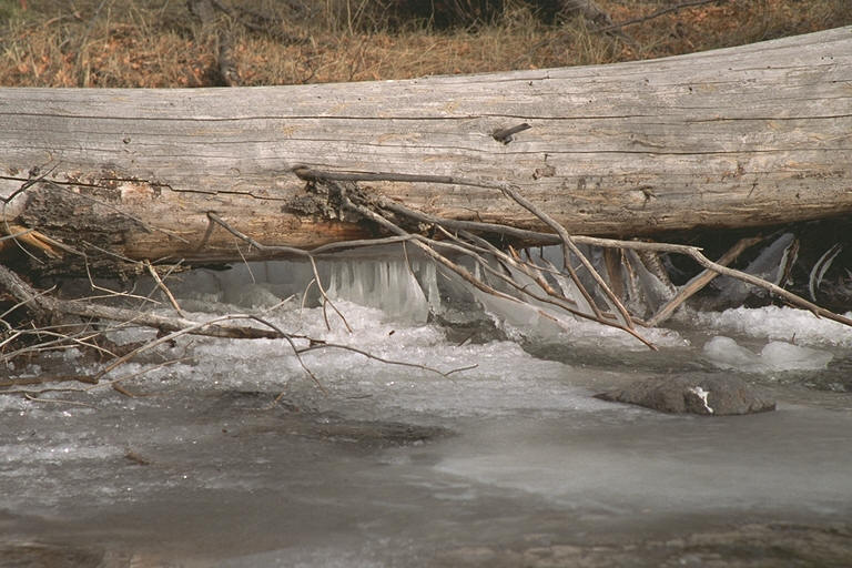
Driving on, we cross a small creek and note a series of mini-falls and
patches of ice-encrusted surface. We stop to take some pictures where I note
little icicles underneath a log, which has fallen across the creek.
Underneath some sections of ice we can see the water coursing underneath and
bubbles of air entrapped – maybe until spring? Picture time again of
course.
Continuing,
we go up above the bridge and are now into the forest. Soon we come upon a
massive stand of aspen, their stark, white, now leafless trunks stretching
forlornly up to the blue sky above, contrasting dramatically with the greens
and browns of the encircling conifers. How beautiful it must be here during
the autumnal change with the multitude of golden charms all “quaking” in
time to the breezes wafting up and down the mountainside. I wish I could
return during that period – whenever it might be. Perhaps next year?
Driving on, we cross a small creek and note a series of mini-falls and
patches of ice-encrusted surface. We stop to take some pictures where I note
little icicles underneath a log, which has fallen across the creek.
Underneath some sections of ice we can see the water coursing underneath and
bubbles of air entrapped – maybe until spring? Picture time again of
course.
 Now
we’re heading down the mountain and soon come back into the town of
Escalante – time to head “home”. The sky above has cleared quite a bit
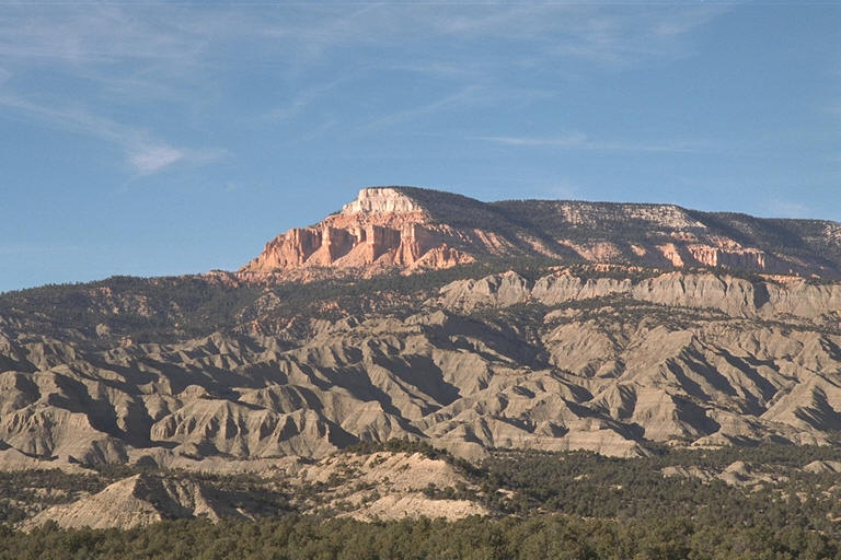
and the sun beats down warmly making me sleepy. Off to the right the
promontory known as Powell Point juts out proudly and is “shining”
brilliantly, its predominately rose-colored cliffs resplendent in the bright
afternoon sunlight, contrasting pointedly with the dark, volcanic-looking
rocks below whose gullies are visible only as dark shadow pools due to the
sun's lowering angle. A beautiful day. A good day’s drive. Nap time!
Now
we’re heading down the mountain and soon come back into the town of
Escalante – time to head “home”. The sky above has cleared quite a bit
and the sun beats down warmly making me sleepy. Off to the right the
promontory known as Powell Point juts out proudly and is “shining”
brilliantly, its predominately rose-colored cliffs resplendent in the bright
afternoon sunlight, contrasting pointedly with the dark, volcanic-looking
rocks below whose gullies are visible only as dark shadow pools due to the
sun's lowering angle. A beautiful day. A good day’s drive. Nap time!
Chris