
 On the way just after 10 under a cloudy sky, the temperature at 62°. It's going to be a quite pleasant
day in the Tucson area, though with the thin layer of clouds covering most of the sky it's not prime for picture taking. Can't have everything I
suppose. My plan is to head for the East Unit of Saguaro NP, about 15 miles from the motel, and drive around the 8-mile Cactus Forest Loop there.
After getting my fill in the east I will head over to the West Unit, about xx miles, and take the "tour" over there, the Scenic Bajada Loop Drive. I
will of course make a stop at each of the visitor centers and, if the mood strikes, perhaps take one or more of the short hikes available at each
unit.
Pulling up to the East Unit Visitor Center, I have to drive carefully through the congestion of bikers all around. The East Unit is right next to Tucson - though it's less densely populated eastern edge - and so it's not surprising that I'm not just one of a few visitors. However, it is not crowded, and once I get onto the Cactus Forest Drive I am mostly left to my own devices as I pull over to admire and walk through the prolific Sonoran Desert plants on display all about the loop. When I am on higher ground though I cannot escape the fact that a major metropolitan area is right next door because the vistas to the north and west incorporates parts of the city. It's almost disconcerting.
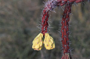
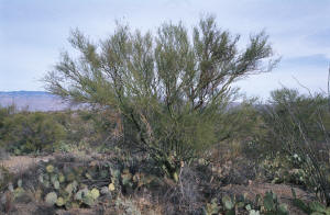 At my first stop I spy a cholla cactus with reddish brown stems, bearing fruits of red and yellow. I've
never seen such a cholla (and I've seen quite a few)! Very cool looking, especially when situated next to a bright green palo verde (one of my
favorite plants), or a towering green saguaro. I must take a picture - of course! From there I follow the road as it winds and dips and rises through
a veritable grove of saguaros, and palo verdes, and acacias, and prickly pears, and brittle bushes, and ocotillos, and barrel cacti, and many other types of
desert flora. It's really quite lush. Whenever I do hike a bit into their midst I have to thread my way carefully because almost all of these desert denizens
have very sharp thorns. Ouch! There's one now!
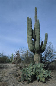
 There are indeed saguaro cacti here. Many, many, many specimens from slender little baby ones, to 6'
"young adults" with no arms, to huge, towering mature ones sprouting over a dozen arms - of all sizes. There are also the skeletal remains of
saguaros, some still standing, showing the internal wooden (yes, wooden) vertical ribs that support the mature saguaro as it reaches up to 50' in
height. I never knew they were "made" of wood! Every mature saguaro that I see has one or more holes in it, drilled into them by the Gila woodpecker
or gilded flicker. These holes are then used as homes by a host of other winged Sonoran residents, after the homebuilders abandon them. Even honeybees
sometimes use them (and I suppose "Killer" bees too). Standing next to some of the larger saguaros, one can't help but feel awe that such a huge plant
can not only grow in this harsh environment, but thrive in it. The accordion-like pleats of the saguaro allow it to expand and fill with water whenever
its large network of shallow but horizontally far reaching roots are able to collect any (up to 95% of a saguaro's weight can be water). It's possible
that one saguaro can collect and store 200 gallons after one good rainfall - enough for a year! Pretty amazing.
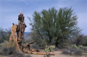 I take the unpaved road to the Mica View Picnic Area. On a day like today this would be a great spot for
a picnic. A bunch of picnic tables and grills scattered about amongst a good collection of tall palo verde trees. There's easy access into the desert
here as a multitude of little "trails" head off into the "forest". I take the time to wander around for a while enjoying the scenery and taking
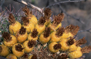
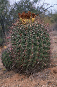
pictures of some interesting specimens, including one where an immature, yet 8' tall saguaro is right next to a 5' barrel cactus. Can you tell which
is which?
A roadrunner runs across the road in front of me as I start to rise partway up the flank of Tanque Verde Ridge, part of the Rincon Mtns here. On the right side now you have periodic good views of Tucson and beyond. Somewhere over there is the Western Unit, my next destination.
 On my way to the West Unit I pass
Davis-Monthan Air Force Base, which must among other purposes, serve as a
graveyard/junkyard for the air force's surplus inventory of planes. Driving by I see many old - some very old - planes of all types, some of which had
obviously been cannibalized for parts. This plane depot is huge and the numbers of old planes there is quite large. Interesting. After getting on then
off again I-10 I finally turn on to Kinney Road, which starts rising up the backside of the Tucson Mtns. where the West Unit is located. The
scenery is pretty nice here, especially as you get higher and are afforded views of the valleys below. I pass Old Tucson Studios and the
Arizona-Sonora Desert Museum before finally arriving at the Visitor Center.
 After purchasing some maps, guides and t-shirts, and getting some driving advice from some very nice
personnel in the Visitor Center, I head out to Bajada Loop Drive. By now the clouds have thickened and the light is quite muted - award winning
picture opportunities is now most unlikely. I've decided that I will take Hohokam Road (part of the loop) to Golden Gate Road, to Picture Rocks Road up
to and out of the northern portion of the West Unit in order to get back on to I-10, and from there head for home - tonight. I'll be getting in past
midnight most likely, but will be able to sleep in my own bed, reintroduce myself to the kitties, and have all of tomorrow to unpack and "unwind" from
the trip. Off I go.
Hohokam Road is a very nice and smooth gravel road that takes you into the hills as it winds through the dense forest of saguaros and other desert plants. There's only a few others on the road, sightseeing as I am, so I am pleasantly alone as I drive through. I pull over at several places to get out and take pictures; hiking into the "thick" of things to get the best shots. The variety of sizes and adornments of the saguaros is quite remarkable. And the numbers! Perhaps to Tucsonans and other Arizonans it's no big deal, but to me it's most amazing. Though I've been to many a desert, many a time, I've rarely visited where the saguaro reigns supreme. It is quite an impressive plant and I am suitably struck.
As the sky is clouded, and the evening drawing near, I don't take too many pictures; mostly ones showing the varied display of appendages on the saguaros. Hence, it doesn't take me too long to reach the end of Hohokam, thus placing me in close proximity to the Interstate. Though cloudy, it's still a pleasant day, and I enjoy the brief, scenic drive through the West Unit. But, all good things must come to an end. Before you can say "Super Big Gulp", I'm on the freeway, headed for California and home.
About 50 miles from Tucson is the split with I-8. Thinking that I might run into rush hour traffic around Phoenix, I decide to keep heading due west and onto the 8. I smile silently to myself as the traffic thins considerably once upon the new freeway. "I'm gonna make some good time now!" The scenery is uninspiring, mostly flat with various peaks and hills in the distance. Still plenty of saguaro though. After about another 50 miles I see that the setting sun, now very close to the horizon (Shades on!) is going to present a pretty good farewell display this evening. "Boy! I've been having pretty good luck with the sunsets this trip!" Driving a little bit further I now see that it's going to be more than pretty good. "I've gotta get off this freeway and set up to take pictures!" Looking at the trusty laptop's display, I see that I'm at least 10 miles from the next exit, at Gila Bend. "Damn!"
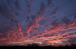 I
put a little more pressure on the gas, keeping an eye on the sunset and looking out for any Highway Patrol types. "Come on exit!" I'm starting to fret
because the clouds in the sky are assuming a bright, fiery, magenta hue on their undersides. I peer ahead intensely, looking for that darn exit,
bumping up the speed some more (90ish). I'm fretting that I'm going to miss what's probably is going to be the best sunset of the entire trip.
"Finally!" I see the exit into Gila Bend and I peel off onto the exit ramp. I head south, under the freeway to the other side where, fortuitously,
there is a big, flat, open spot adjacent to the freeway with an unobstructed view to the southwest - where the sun has already set.
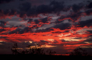 I
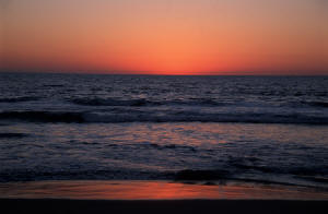
grab my camera and start shooting from my seat, through the open window. "Beautiful!" The sky is totally lit up with a soft fire in a cool, blue sky,
the horizon a bright, though dimming, orange where the sun has just sunk below it. The combination of clouds and colors is awesome. I shoot and look,
and look and shoot, enjoying my last "fling" of the trip. I switch to my longer zoom lens - the expensive one - to get more of the colors in the frame
and because it's more suited for dim light conditions. I get about another 20 shots with it before the colors start to fade. So I put the camera stuff
away, sit back, and enjoy the final moments of this most gorgeous display.
 After
the last wisps of colors are gone, I fire up the Explorer and head back to the freeway. As I get onto the freeway I'm thinking about how much I've
enjoyed the day, the trip back west, the whole darned adventure. Though I still have a long drive ahead of me, I feel energized after experiencing my
last little adventure of the trip, and I crank up some Depeche Mode playing on the CD player as I head west once again towards the sunny, Pacific
shores of California, and my home.
Goodnight and safe journeys to all.
%20C,1,25_750.jpg)