![]()
![]()
![]()
 Checking out just before the 11am deadline I hit the road all gassed up and ready to go. The day was a bright one; a lot of blue
sky with thin, scattered clouds. It was only 39°, but with the sun raining down on you and little wind it was quite
pleasant. Today's first "goal" is to take the Ross Maxwell (first superintendent of Big Bend) Scenic Drive Down to Castolon and Santa Elena Canyon,
returning via the Old Maverick Road, which unlike the former is not paved. Then back through Study Butte to the ghost town of Terlingua. After that?
Well, we'll see how it all goes.
Checking out just before the 11am deadline I hit the road all gassed up and ready to go. The day was a bright one; a lot of blue
sky with thin, scattered clouds. It was only 39°, but with the sun raining down on you and little wind it was quite
pleasant. Today's first "goal" is to take the Ross Maxwell (first superintendent of Big Bend) Scenic Drive Down to Castolon and Santa Elena Canyon,
returning via the Old Maverick Road, which unlike the former is not paved. Then back through Study Butte to the ghost town of Terlingua. After that?
Well, we'll see how it all goes.
My first stop is at the old homestead site of the Sam Nail Ranch. A very short hike from the road brings me to the site. There's 2 windmill towers, one of which is still pumping water to the fig and pecan trees, planted by the Nails, still growing and creating a little oasis amongst the harsh desert environment. The bushes and trees are alive with the rustle of birds and other creatures as I walk the circular path around the site. There is one partial wall remaining of the adobe house that the Nails resided in. I inspect it closely because I don't think I've ever actually been up close and personal with adobe. "It's just mud!" Amazing!
Back on the road to Castolon I next stop at the overlook for the old Homer Wilson Ranch. While there is a trail down there I declined the opportunity to take a closer look. Instead, I satisfied myself with the view from above. There is one main building that seems fairly intact and according to the sign this was the foreman's house. Just beyond the ranch overlook is Sotol Vista Overlook where I am delivered an expansive panoramic view looking south and east towards the Rio Grande. Very impressive. There are quite a few of the vista's namesake plants about. the sotol, many with the flower spike from last year's bloom. One rather impressive stalk deserves, I decide, recording for posterity.
_1600.jpg)
The road drops down quickly from the vista onto a broad plain, dotted with small hills and hummocks, that rolls towards the Rio Grande still about 13 miles distant. Just as the road curves southward again I see the turnoff for Burro Mesa Pouroff - whatever that is. Since the road is paved I decide to go ahead and see what's there. The turnoff ends in about a mile, and from there a short, 1/2 mile trail leads to the pouroff, which is where the wash from above pours off the mesa looming high above. Due to the higher rock being so hard and resistant to erosion - a dry falls.
 I start along the trail, which is nearly level, as it cuts across the desert floor to the nearby Burro
Wash. Crossing the wash, the trail then follows along its left side until it enters the wash at the canyon's entrance. Walking is easy as the gravel
in the wash is firm and level. On the left side the canyon walls vertically a few hundred feet to the Burro Mesa above. The rocks are a variety of
colors and very rough. On the right the canyon slopes up steeply, though not quite so precipitously nor as high as the left. Here the rocks are a very
darkly-colored conglomerate of cobbles and boulders; quite different from the opposite side.
I start along the trail, which is nearly level, as it cuts across the desert floor to the nearby Burro
Wash. Crossing the wash, the trail then follows along its left side until it enters the wash at the canyon's entrance. Walking is easy as the gravel
in the wash is firm and level. On the left side the canyon walls vertically a few hundred feet to the Burro Mesa above. The rocks are a variety of
colors and very rough. On the right the canyon slopes up steeply, though not quite so precipitously nor as high as the left. Here the rocks are a very
darkly-colored conglomerate of cobbles and boulders; quite different from the opposite side.
There is an abundance of vegetation in and around the wash and I am enjoying myself immensely as I hike up it, especially now that the sun has warmed things up quite a bit - to almost 50°. It has turned out to be a very pleasant hike on a very pleasant day. The going is easy, the birds are twittering, and from the deep greens of the cholla cacti, to the orangey-browns of the fallen leaves, to the yellows and reds in the rocks above, there is a variety of colors - and textures - to be enjoyed. I pass one cholla with an empty bird's nest in it. Cool!
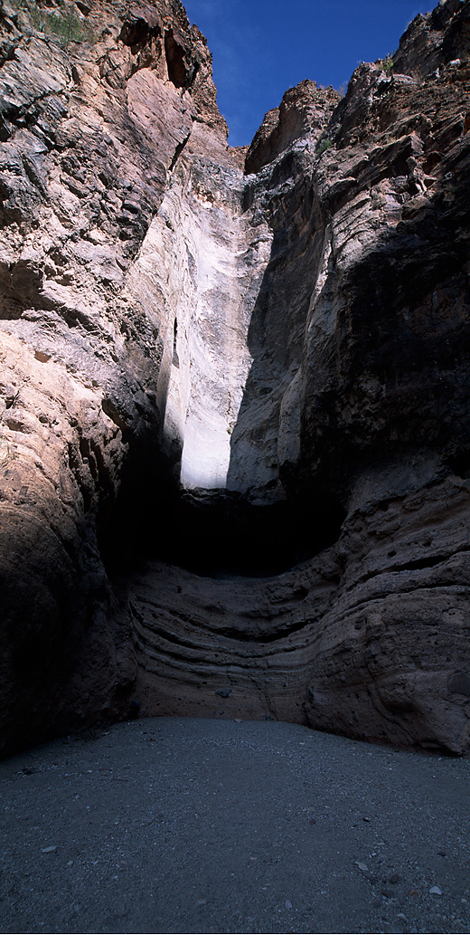 And so after only half a mile I come to the head of the canyon, trail's end, and the pouroff. It's dark
and vertical and semi-circular, with several ledges eroded into it. There's only sand and gravel at the bottom of it so I go and stand right
underneath it and look straight up. Wow.! I can just imagine the torrents that sometime come rushing over the edge from above. I'm sure it would be a
very cool thing to see, though one would have to be ready to very quickly scramble up the south side of the wash to get out of harm's way. You could
do it though I think.
And so after only half a mile I come to the head of the canyon, trail's end, and the pouroff. It's dark
and vertical and semi-circular, with several ledges eroded into it. There's only sand and gravel at the bottom of it so I go and stand right
underneath it and look straight up. Wow.! I can just imagine the torrents that sometime come rushing over the edge from above. I'm sure it would be a
very cool thing to see, though one would have to be ready to very quickly scramble up the south side of the wash to get out of harm's way. You could
do it though I think.
The road drops down some more and skirts around Goat Mountain, whose facade is the result of an interesting combination of volcanic activity and stream erosion, giving it it's multi-colored, filled-in canyon look that it has today. The immediate area is obviously of volcanic origin, there are literally fields of dark rocks and boulder mixed in with the regular desert landscape. Volcanic dikes, intrusions of magma into the original sedimentary rocks are very prevalent here - a very scenic, short stretch of road.
Next stop is the Mules Ears Overlook. (This is a great drive!) The Mules Ears are two huge eroded chunks of lava adjacent to each other so as to give the appearance of, well, 2 mule's ears, They are very prominent throughout the park, from many different vantages. I drive up the short spur to the overlook which still leaves you about 4 or 5 miles away from them. There's a trail that puts you to within a mile, but it's not for me today. I take a couple of pictures and continue on towards Castolon.
 Next stop (Will they never stop?) is for Tuff Wash, a narrower and deeper wash than the normal due to the
underlying rock being composed of tuff (rock from volcanic ash), which is harder and more resistant to erosion than the shales and granites
found in other washes in the area. The 3 overlooks are perched right at the edge, which is vertical to the bottom of the wash below. Not for sufferers
of vertigo! There are some muddy brown pools in the wash, a result perhaps of the recent rainfall. A short distance the wash I pass some rounded, pale
white mounds, bereft of any vegetation, some dusted with a collection of dark and rusty brown "sprinkles", as if by a confectioner. This must be some
more tuff (it's the same shade as Tuff Wash). Above to the left, up high, is Castolon Peak, a very eroded plug of rock showing a multitude of
volcanic and erosion layers. I can now also see more clearly Santa Elena Canyon, which is now a big notch, where before, from Sotol Vista, it
was just a tiny notch. Getting there!
Next stop (Will they never stop?) is for Tuff Wash, a narrower and deeper wash than the normal due to the
underlying rock being composed of tuff (rock from volcanic ash), which is harder and more resistant to erosion than the shales and granites
found in other washes in the area. The 3 overlooks are perched right at the edge, which is vertical to the bottom of the wash below. Not for sufferers
of vertigo! There are some muddy brown pools in the wash, a result perhaps of the recent rainfall. A short distance the wash I pass some rounded, pale
white mounds, bereft of any vegetation, some dusted with a collection of dark and rusty brown "sprinkles", as if by a confectioner. This must be some
more tuff (it's the same shade as Tuff Wash). Above to the left, up high, is Castolon Peak, a very eroded plug of rock showing a multitude of
volcanic and erosion layers. I can now also see more clearly Santa Elena Canyon, which is now a big notch, where before, from Sotol Vista, it
was just a tiny notch. Getting there!
_750.jpg)
I pull into Castolon, formerly an army staging area during the hunt for Pancho Villa by General John J. Pershing. Some of the buildings from that era still remain. I chat for a bit with a couple, NPS Volunteers, asking them about where to go from here, what's to see on the way out, etc. I tell them about how I just missed the sunset's colors yesterday and they knew just where and what I was talking about. Dang again! I get a couple of brochures from them and buy 2 souvenir Big bend shot glasses from the old country store there, then head on out to Santa Elena Canyon, only 8 more miles. Leaving Castolon I glance at the thermometer - 60°!
 Finally, I pull into the parking area for Santa Elena Canyon. There are again a dozen or so vehicles (don't forget, that's vee·hik·ulls).
I grab my new Nikon 80-200mm zoom, the expensive one, because the canyon itself is no longer lit by the sun, here at least, and that puppy excels in
low light conditions (which is why it cost so darned much). The Mexican side of the river, from the canyon and eastwards, is a massive, towering wall
of chocolate brown and tawny colored rock. The Rio Grande flood plain here is very wide, though mostly on the American side. There's only a narrow
strip along the Mexican side where I can see several horses grazing. (Wild or domesticated?) Several families used to farm this area, using the
relatively fertile floodplain to raise a variety of crops, as well as raise horses and cattle.
Finally, I pull into the parking area for Santa Elena Canyon. There are again a dozen or so vehicles (don't forget, that's vee·hik·ulls).
I grab my new Nikon 80-200mm zoom, the expensive one, because the canyon itself is no longer lit by the sun, here at least, and that puppy excels in
low light conditions (which is why it cost so darned much). The Mexican side of the river, from the canyon and eastwards, is a massive, towering wall
of chocolate brown and tawny colored rock. The Rio Grande flood plain here is very wide, though mostly on the American side. There's only a narrow
strip along the Mexican side where I can see several horses grazing. (Wild or domesticated?) Several families used to farm this area, using the
relatively fertile floodplain to raise a variety of crops, as well as raise horses and cattle.
 I start walking across the floodplain, which is also where Terlingua Creek empties into the Rio, though
today there's nothing in it to empty. After a few hundred yards of easy hiking I come to the entrance to Santa Elena Canyon. With the sun now hidden
behind the dark walls of the canyon, towering over 1000' above me, it almost seems a bit forbidding. The muddy brown Rio Grande flowing placidly yet
steadily out of the mouth of the canyon bears off to my left as I nonetheless enter. A series of concrete steps and ramps practically hurls me up to
where the trail then follows the side of the right canyon wall, the American side. From this point on though the trail drops steadily back down
towards the river, but at a slow enough rate so that the going is very easy. As it gets closer to river level it turns from a rocky path to a packed
dirt one that shortly splits into several paths that wind their way through the sometimes thick vegetation, including some of the same reeds I hiked
through yesterday.
I start walking across the floodplain, which is also where Terlingua Creek empties into the Rio, though
today there's nothing in it to empty. After a few hundred yards of easy hiking I come to the entrance to Santa Elena Canyon. With the sun now hidden
behind the dark walls of the canyon, towering over 1000' above me, it almost seems a bit forbidding. The muddy brown Rio Grande flowing placidly yet
steadily out of the mouth of the canyon bears off to my left as I nonetheless enter. A series of concrete steps and ramps practically hurls me up to
where the trail then follows the side of the right canyon wall, the American side. From this point on though the trail drops steadily back down
towards the river, but at a slow enough rate so that the going is very easy. As it gets closer to river level it turns from a rocky path to a packed
dirt one that shortly splits into several paths that wind their way through the sometimes thick vegetation, including some of the same reeds I hiked
through yesterday.

 Less than a mile from the parking lot the trail end abruptly at the water's edge so I find a nice, big
rock sticking out into the river a ways to set up for some shots of the river and canyon upstream where the sun is still lighting up a portion of the
canyon wall. I take a series of bracketed shots of the view upstream, being careful to steady myself against the boulder I've crawled out upon since
the required shutter speeds are so slow. If only one of them comes out like I see it now it will be an extraordinary shot - the dark, vertical canyon
framing the still, almost reflective brown surface of the river, some well-situated plants and boulders, and in the background the sun still shining
on the canyon walls as it takes a turn towards the left. Let's hope.
Less than a mile from the parking lot the trail end abruptly at the water's edge so I find a nice, big
rock sticking out into the river a ways to set up for some shots of the river and canyon upstream where the sun is still lighting up a portion of the
canyon wall. I take a series of bracketed shots of the view upstream, being careful to steady myself against the boulder I've crawled out upon since
the required shutter speeds are so slow. If only one of them comes out like I see it now it will be an extraordinary shot - the dark, vertical canyon
framing the still, almost reflective brown surface of the river, some well-situated plants and boulders, and in the background the sun still shining
on the canyon walls as it takes a turn towards the left. Let's hope.
Though I've put on my fleece jacket for the hike into the canyon, just sitting there in the cool stillness, without benefit of the sun's warmth, I start to feel a little chilled so I start my way back. I take a different path back, one where I need to duck and slither through some tight brush spots. Fun! By the time I get back to the truck though I've warmed all back up and am glad to be rid of the now too hot fleece. Because I do hate to backtrack I make a turn onto the Old Maverick Road, which the volunteer couple assured me had just been graded and was a nice drive too.
 Almost immediately a glance over to the left stirs an ancient and vague memory, "I've been here before!"
It comes to me that this is the way I left the park the last (and only) time I was here, 15 years ago. Consequently, I expect to see an old residence
on the way out and sure enough, in about 7 miles in I come to the Lunas J, a low-slung hut made completely from native materials. I remember that
then you could go inside it though you'd have to watch your head as it couldn't be more than 4 1/2' from dirt floor to the ceiling in there, but it's
now screened off from entry. Stupid vandals! The old man who built it lived here until his death at 108! I take a picture and proceed on my way.
Almost immediately a glance over to the left stirs an ancient and vague memory, "I've been here before!"
It comes to me that this is the way I left the park the last (and only) time I was here, 15 years ago. Consequently, I expect to see an old residence
on the way out and sure enough, in about 7 miles in I come to the Lunas J, a low-slung hut made completely from native materials. I remember that
then you could go inside it though you'd have to watch your head as it couldn't be more than 4 1/2' from dirt floor to the ceiling in there, but it's
now screened off from entry. Stupid vandals! The old man who built it lived here until his death at 108! I take a picture and proceed on my way.
 The sun is setting now and it looks as if it's going to be another beautiful sunset. The road is pretty
smooth - for a gravel road - and I can easily do 35-40 mph. I'll be "home" in no time! I've already decided that I'm going to stay another night in
Study Butte (How do you pronounce that?) because I didn't have a chance to get to Terlingua Ghost Town, and the nice couple at Castolon said the drive
up from Lajitas to Presidio, which follows the Rio Grande through Big Bend Ranch State Natural Area, is very scenic and not to be missed. So I won't.
I end up getting the same room for the same reduced rate. The sun by now is finishing a grand departure, now only a small, but still very bright
orange glow in the west. The local paper out of Alpine (about 80 miles north) says there's a chance of snow tomorrow night so I'm not so sure about
Guadalupe Mtns, but as always, "Whatever!" I'll just keep my options open and we'll see what it all turns out to be.
The sun is setting now and it looks as if it's going to be another beautiful sunset. The road is pretty
smooth - for a gravel road - and I can easily do 35-40 mph. I'll be "home" in no time! I've already decided that I'm going to stay another night in
Study Butte (How do you pronounce that?) because I didn't have a chance to get to Terlingua Ghost Town, and the nice couple at Castolon said the drive
up from Lajitas to Presidio, which follows the Rio Grande through Big Bend Ranch State Natural Area, is very scenic and not to be missed. So I won't.
I end up getting the same room for the same reduced rate. The sun by now is finishing a grand departure, now only a small, but still very bright
orange glow in the west. The local paper out of Alpine (about 80 miles north) says there's a chance of snow tomorrow night so I'm not so sure about
Guadalupe Mtns, but as always, "Whatever!" I'll just keep my options open and we'll see what it all turns out to be.
Night!
_1600.jpg)