![]()
![]()
![]()
 We
get an earlier start today (a bit anyway) and head out 10ish. The weather is
beautiful! It's a touch cooler but the sun is shining oh so brightly and the
sky is a bright, bold blue unsullied by even a trace of fleecy wisps. We've
been blessed with wonderful weather this trip! After gassing up and getting
my "Super Tanker" we head north out of Sedona on 89A which travels
through the very scenic Oak Creek Canyon as it heads toward Flagstaff. Our
destinations today are Sunset Crater NM and Wupatki NM.
We
get an earlier start today (a bit anyway) and head out 10ish. The weather is
beautiful! It's a touch cooler but the sun is shining oh so brightly and the
sky is a bright, bold blue unsullied by even a trace of fleecy wisps. We've
been blessed with wonderful weather this trip! After gassing up and getting
my "Super Tanker" we head north out of Sedona on 89A which travels
through the very scenic Oak Creek Canyon as it heads toward Flagstaff. Our
destinations today are Sunset Crater NM and Wupatki NM.
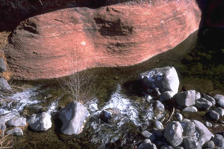
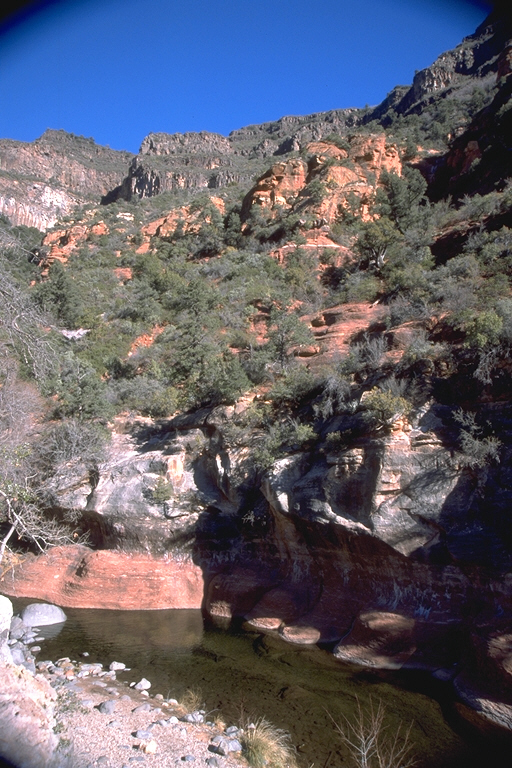 We
wind slowly up Oak Creek Canyon stopping at one point to hike over to the
cliff edge above the creek to take a look-see. There is snow on the ground
and I am cautious as I position myself at the edge to capture on film the
view. The canyon wall on the other side here rises several hundred feet to
the top and is colored in reds and yellows, dotted with trees and shrubs of
all types sprouting from the near vertical sides. Below, the waters of Oak
Creek flow placidly along, barely tumbling over slight obstructions of small
boulders in it's path. Oak and other hardwood trees are visible below, their
branches now covered only with bare traces of the snow which fell earlier
this week.
We
wind slowly up Oak Creek Canyon stopping at one point to hike over to the
cliff edge above the creek to take a look-see. There is snow on the ground
and I am cautious as I position myself at the edge to capture on film the
view. The canyon wall on the other side here rises several hundred feet to
the top and is colored in reds and yellows, dotted with trees and shrubs of
all types sprouting from the near vertical sides. Below, the waters of Oak
Creek flow placidly along, barely tumbling over slight obstructions of small
boulders in it's path. Oak and other hardwood trees are visible below, their
branches now covered only with bare traces of the snow which fell earlier
this week.
We reach Flagstaff and for a while drive on old Rt. 66 before leaving town, heading north again, on Rt. 89 (no A). We have climbed up to about 7000 feet and it has gotten cold, high 20's, brrrrr! Just a bit out of town we take the turnoff to Sunset Crater NM which will also bring us in the back way to Wupatki. The visitor center is just inside the park so we get out of the truck and hurry in. "Man it's cold out there!" Inside we are greeted by a very nice ranger, Anita, who gladly shares her knowledge of the park with us. I purchase a Golden Eagle pass, which will allow me free entry into any federal fee area for a year. Bonus!
 Having
been filled in by Ranger Anita, we head east towards Sunset Crater and the
short nature walk at its base. On the way there we pass by a huge flow of
mostly aa (no that's not a typo) lava, the Bonito Lava Field. It's comprised
of huge masses of jagged and crenulated, dark-colored lava piled high on top
of another. What a sight it must have been when it was flowing - a river of
basalt! At the nature walk we are afforded a nice view of Sunset Crater, a
1000 foot tall cinder cone. There are in fact hundreds of cinder cones in the
area, all part of the San Francisco Volcanic Area, of which Sunset is the
most recently erupted. It rises quickly skyward from where we stand, a dark
black mound of pebbles and stones (cinders) almost devoid of any plant life.
The top is a rusty-red color due to the iron in the cinders there which have
oxidized over time (rusted), hence it's name, as the top is said to fairly
glow in the reddish rays of the setting sun. We linger not long here 'cause
the wind is starting to whip us about the ears, herding us back to the warm
comfort of the Explorer.
Having
been filled in by Ranger Anita, we head east towards Sunset Crater and the
short nature walk at its base. On the way there we pass by a huge flow of
mostly aa (no that's not a typo) lava, the Bonito Lava Field. It's comprised
of huge masses of jagged and crenulated, dark-colored lava piled high on top
of another. What a sight it must have been when it was flowing - a river of
basalt! At the nature walk we are afforded a nice view of Sunset Crater, a
1000 foot tall cinder cone. There are in fact hundreds of cinder cones in the
area, all part of the San Francisco Volcanic Area, of which Sunset is the
most recently erupted. It rises quickly skyward from where we stand, a dark
black mound of pebbles and stones (cinders) almost devoid of any plant life.
The top is a rusty-red color due to the iron in the cinders there which have
oxidized over time (rusted), hence it's name, as the top is said to fairly
glow in the reddish rays of the setting sun. We linger not long here 'cause
the wind is starting to whip us about the ears, herding us back to the warm
comfort of the Explorer.
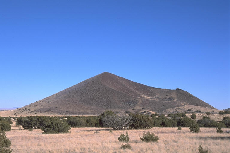
Continuing we start losing elevation as we head towards Wupatki where we will see some very fine examples of pueblo structures. After a bit the Painted Desert can be seen way off in the distance, the panorama of colors visible hinting at the geologic wonders it holds for us in a future visit. The flora has now changed from those found in a Ponderosa Pine forest to Pinyon Pine-Juniper species. I notice a dirt road on my right as I speed by which seems to lead towards a nice looking cinder cone not too far off in the distance. I brake, pull a U-ey and take the spur road which is made of the cinders we have seen all about. Instead of dirt, the ground all around is composed of these dark, nearly black cinders and their crushed and decomposed remnants. We come to a good vantage point of the cinder cone so of course I stop and Tom and I take a series of shots.
 Pulling
out the laptop and firing up Streets Atlas USA I see that there are a series
of roads, some of which can be taken the "scenic way" back towards
the main road. Turning on the GPS I can see exactly which one of them we are
on at present so I decide to do the right thing and take the path less trod
and head east. Almost immediately we are startled by a large flock of
Mountain Bluebirds which rises up, out of nowhere it seems, as we drive by.
The startlers are now the startlees! The birds are a panoply of flashing
blues as they flit about until settling into new locations in the bushes and
grasses nearby - away from the disturbance. What a stunningly pretty sight it
is! It's almost worth the drive today all by itself!
Pulling
out the laptop and firing up Streets Atlas USA I see that there are a series
of roads, some of which can be taken the "scenic way" back towards
the main road. Turning on the GPS I can see exactly which one of them we are
on at present so I decide to do the right thing and take the path less trod
and head east. Almost immediately we are startled by a large flock of
Mountain Bluebirds which rises up, out of nowhere it seems, as we drive by.
The startlers are now the startlees! The birds are a panoply of flashing
blues as they flit about until settling into new locations in the bushes and
grasses nearby - away from the disturbance. What a stunningly pretty sight it
is! It's almost worth the drive today all by itself!
We continue on a totally washboard surface now, until I spy some lava blobs sitting on the side of a short hill on our right. Time to explore! We get out and walk up the very loose surface. It's hard going, but we are rewarded with a very nice view looking back towards the San Francisco Mtns. (Did you know that the mountains used to be a single volcano? I didn't) Scattered about one can see many cinder cones dotting the landscape, including of course, Sunset Crater. To the right we can just see the Painted Desert, a touch closer now. It's warmer, though not warm, so we descend from the mount after a short interlude of enjoying the scenery of fiery origin.
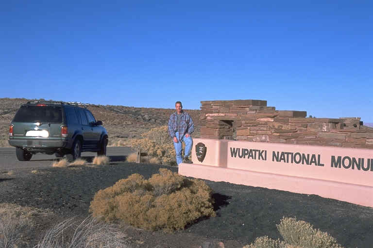 Hooking
up with the main road we keep losing altitude and find ourselves at the
boundary of Wupatki National Monument. I'm in a touristy mood so I get Tom to
take my picture standing next to the entrance sign. The area is now desert
scrub and grasses overlying the basaltic flows which formed the contours upon
which I'm driving, the evidence of which is seen in the various outcroppings.
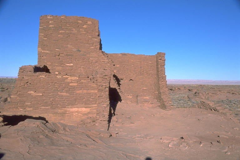
Just ahead though the desert rocks meet up with the cinderscape, we are I
suppose at the boundary of the Painted Desert (doesn't that name just conjure
up a grand vision?), and here is where the first ruin of the day is visited,
Wukoki Pueblo. Wukoki was built on top of an outcropping of Moenkopi
sandstone from Moenkopi sandstones and siltstones. As such it is a dark
orangey-red and it seems to loom up from a bed of surrounding black cinders.
Originally 3 stories high, even in its reduced state of height it commands an
imposing view of the surrounding countryside. It must have been a beacon for
the countryside, looking even today, in its ruined state like a miniature
castle. We take a quick tour in, on and around the ruins, contemplating on
how it must have been hundreds of years ago when this was somebody's home.
Hooking
up with the main road we keep losing altitude and find ourselves at the
boundary of Wupatki National Monument. I'm in a touristy mood so I get Tom to
take my picture standing next to the entrance sign. The area is now desert
scrub and grasses overlying the basaltic flows which formed the contours upon
which I'm driving, the evidence of which is seen in the various outcroppings.
Just ahead though the desert rocks meet up with the cinderscape, we are I
suppose at the boundary of the Painted Desert (doesn't that name just conjure
up a grand vision?), and here is where the first ruin of the day is visited,
Wukoki Pueblo. Wukoki was built on top of an outcropping of Moenkopi
sandstone from Moenkopi sandstones and siltstones. As such it is a dark
orangey-red and it seems to loom up from a bed of surrounding black cinders.
Originally 3 stories high, even in its reduced state of height it commands an
imposing view of the surrounding countryside. It must have been a beacon for
the countryside, looking even today, in its ruined state like a miniature
castle. We take a quick tour in, on and around the ruins, contemplating on
how it must have been hundreds of years ago when this was somebody's home.
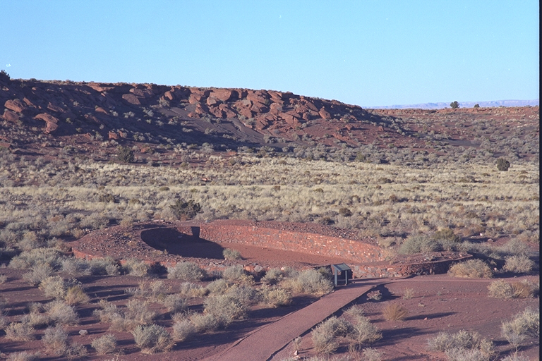
 Now
we head for and arrive at the park headquarters where the Wupatki ruins are.
These are the largest ruins in the area and they are impressive - a long row
of rooms and chambers, some up to 3 stories tall, some intact, others barely
recognizable. There is a ball court down the way and a big, communal meeting
area. All structures are built from the nearby Moenkopi rocks and are
mortared with local red-colored mud. The walls look to me like they are built
of red-colored slate with matching grout. There are windows, doorways,
built-in shelves, even a system to allow indoor fires to ventilate properly
without a chimney. It's really quite impressive. According to
archaeologists this site was home for up to 125 people. Imagine!
Now
we head for and arrive at the park headquarters where the Wupatki ruins are.
These are the largest ruins in the area and they are impressive - a long row
of rooms and chambers, some up to 3 stories tall, some intact, others barely
recognizable. There is a ball court down the way and a big, communal meeting
area. All structures are built from the nearby Moenkopi rocks and are
mortared with local red-colored mud. The walls look to me like they are built
of red-colored slate with matching grout. There are windows, doorways,
built-in shelves, even a system to allow indoor fires to ventilate properly
without a chimney. It's really quite impressive. According to
archaeologists this site was home for up to 125 people. Imagine!
 After
leaving the Wupatki (which by the way means "tall house") we head
on back to Sedona, passing through Flagstaff again and winding our way back
through the now darkened Oak Creek Canyon. Tom picks Italian for dinner so we
dine at Spices Restaurant. I had a very tasty Minestrone soup and some
delectable shrimp in a garlic, mushroom cream sauce over peas and bowtie
pasta. Yummy! (Hey, don't freak. I never said I disliked Italian if you
recall). A fine way to end a very fine, adventure-filled vacation!
After
leaving the Wupatki (which by the way means "tall house") we head
on back to Sedona, passing through Flagstaff again and winding our way back
through the now darkened Oak Creek Canyon. Tom picks Italian for dinner so we
dine at Spices Restaurant. I had a very tasty Minestrone soup and some
delectable shrimp in a garlic, mushroom cream sauce over peas and bowtie
pasta. Yummy! (Hey, don't freak. I never said I disliked Italian if you
recall). A fine way to end a very fine, adventure-filled vacation!