![]()
![]()
![]()
 I
have found calm amidst the clatter. It's at a trailhead off of Schnebly Hill
Road, just before the pavement ends. The views are tremendous and are mostly
unspoiled by the clutter of the town's buildings and infrastructure. The
newly-paved parking lot is surrounded by a natural garden of cacti,
succulents and other desert flora. There are several picnic benches spaced
far enough apart to allow one to enjoy a bounty of food and scenery while
wrapped in one's thoughts or whilst enjoying the pleasantness of your
traveling companion. While there were quite a few vehicles and groups of
people it seemed as if everyone was under the enchantment of the soaring
backdrops and all was muted, calm, serene. Tom and I shot some pictures,
hoping to record the beauty present. I wanted to linger some, but we had a
hill to climb so...
I
have found calm amidst the clatter. It's at a trailhead off of Schnebly Hill
Road, just before the pavement ends. The views are tremendous and are mostly
unspoiled by the clutter of the town's buildings and infrastructure. The
newly-paved parking lot is surrounded by a natural garden of cacti,
succulents and other desert flora. There are several picnic benches spaced
far enough apart to allow one to enjoy a bounty of food and scenery while
wrapped in one's thoughts or whilst enjoying the pleasantness of your
traveling companion. While there were quite a few vehicles and groups of
people it seemed as if everyone was under the enchantment of the soaring
backdrops and all was muted, calm, serene. Tom and I shot some pictures,
hoping to record the beauty present. I wanted to linger some, but we had a
hill to climb so...
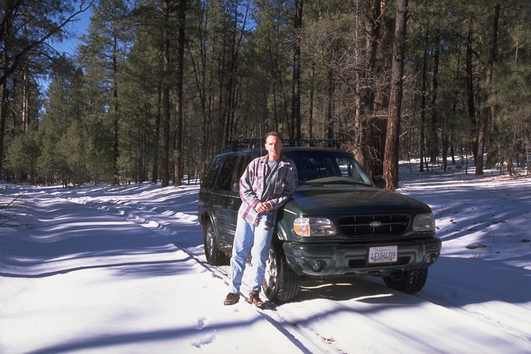
We start up the hill from the parking lot and immediately lose pavement. The road is very rough; we're driving over the remnants of pavement. It looks like it used to be a regular road here. I wonder what happened? We're trending in a northeasterly direction as we wind up the mountain so the snow which fell last week is still very much present on those parts which receive little or no sun. It's not deep however, and the stretches of snow are mostly short (darnit!), so we have no problem navigating uphill (I'm in 4WD of course and I'm sure that it's helping quite a bit).
 We
stop a few times on our way up to take pictures. Tom is a madman with the
camera. He puts me to shame with the number and variety of shots he takes -
my excuse is that I've seen all this type of stuff before so I'm just being
selective(?). The first part is through Bear Wallow Canyon and we have nice
views of the sunlit eastern wall as we climb. Then we start switchbacking up
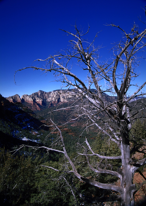
towards Schnebly Hill Vista, rising more rapidly now. We stop almost all the
way to the vista where there's a grand view of Oak Creek Canyon and Rt. 89A
far down below. The town of Sedona becomes visible after a bit, but it's
presence is not as jarring as it was yesterday - it blends into the scenes
better and becomes, "Oooh. Look. I can see the town!" :). instead
of, "Eeew. Look. I can see the stupid town!"
We
stop a few times on our way up to take pictures. Tom is a madman with the
camera. He puts me to shame with the number and variety of shots he takes -
my excuse is that I've seen all this type of stuff before so I'm just being
selective(?). The first part is through Bear Wallow Canyon and we have nice
views of the sunlit eastern wall as we climb. Then we start switchbacking up
towards Schnebly Hill Vista, rising more rapidly now. We stop almost all the
way to the vista where there's a grand view of Oak Creek Canyon and Rt. 89A
far down below. The town of Sedona becomes visible after a bit, but it's
presence is not as jarring as it was yesterday - it blends into the scenes
better and becomes, "Oooh. Look. I can see the town!" :). instead
of, "Eeew. Look. I can see the stupid town!"
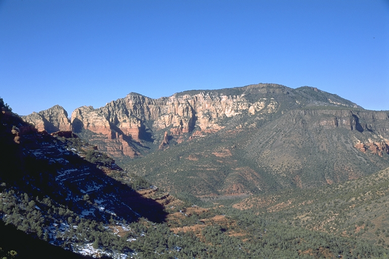
There's one last, long stretch of snow-covered road before we reach the vista so I gun the gas a bit to keep my momentum and we barrel on through until we reach it. At the top we are stopped by a young fella who walks over from his little mini-rv. "How is it?" "You mean the road?" "Yeah. How's the road going down" I look at his vehicle. "You drove that up here?" "Yeah" "Well, if you made it up here you should be ok going down. Just put her in low and take it nice and easy" ["What was he thinking bringing that thing up here"] "Yeah, but I'm a little worried about that stretch right down there [pointing] "Well actually, that's your worst section as far as snow goes. Most of the way is clear of snow. It's just that it gets pretty bumpy. But, you should be ok if you go nice and slow" ["I mean real slow dude"] "Ok, thanks!" "No problem" We pull into the vista parking and get out to savor the view. We have about a 250° panorama unfolding before us and I grab my camera and head for the edge to drink it in for a while. I take a couple of shots and while Tom goes about his business I head back to the truck to jot down my inspirations.
We soon head out and continue to gain elevation a bit. Soon we have gotten high enough so that the road is "permanently" covered in snow. Time for some fun! I see an untracked side road and we head in for a few hundred yards, laying down some tracks to go along with the various animal tracks visible as we glide and slide on past them. Back on the main road we go along for a while on the top of the hill which is pretty flat. We are now high enough that we are amidst a forest of conifers and with a blanket of snow all about, it is very peaceful. Calm. Soothing. A very, very pleasant drive now.
Soon we start heading down towards I-17. Passing a little lake, whose surface is covered by a thin, silvery sheen of ice, I espy another untrammeled pathway heading off into the trees. "Time to go exploring Tom!" We go slowly through a "tunnel" of trees and snow, the branches of the tall pines forming an arching, green vault above, with the white, powdery snow as our floor. We see squirrels running about ahead of us, sometimes dashing across our path as we venture inward. We pass a private inholding to our left, comprised mostly of snow-covered meadows, encircled by the quiet forest we are slowly penetrating. The way opens up after a bit so I park and we prepare and eat lunch, tasty sandwiches made of leftover Honey-Baked ham and turkey (from the New Year's Eve festivities), joined with potato chips (gotta have chips with sandwiches), washed down with a refreshing, soothing Corona. Natalie Merchant plays as we munch, savoring the food and the moment. We are alone here, on top of the mountain, save for each other's company and the company of nature's calm beauty enveloping us. Aaaah! Precious moments like these are too few, but are rejuvenating to body and soul when experienced. Let's go find some more!
A short time later we arrive at the on-ramp to I-17. Our next destination is Stoneman Lake which is south on I-17, then east on Rt. 213 about 10 miles. I pull out the Coconino National Forest map I had purchased yesterday and looked at the boring route we were about to take. Then I looked to the north of the lake and saw all the Forest roads going hither and yon. Then I saw that the road we were on continued on the other side of the freeway and turned south... I traced my finger... Yes... "Tom are you ready to explore?" "Sure" "Okay", and I showed him how the network of Forest roads should bring us to our destination - Stoneman Lake. "Let's go!" And we were off!
The pavement we had just found ended on the other side so we are now running on a snow-covered dirt road in the tracks laid down by previous visitors. We're in 4WD, but initially the going is flat and very easy, and it is hardly necessary. The freeway soon disappears from sight and we are skimming through the woods, with the sun shining brightly in a clear, blue sky on the mantle of snow all about us. The air is crisp, about 42° in temperature, and is sweetly silent save for the occasional call of a passing bird, or the soft thump of melting snow whose icy grip has been loosened from the branches to which it clings by the warming rays of the sun. It's always quieter, more peaceful when snow covers the landscape. It mutes the cacophony. It reduces the roar. It deadens the din.
After a few miles of cruising the tracks get deeper and the road starts curving up, down, and around. Now the 4WD is needed and it is doing a fine job - no problem negotiating the ups and downs, and twists and turns, through the forest. "Good Explorer!" Soon we come to the end of this road, to FS 127 - just like the map says we would. [Whew!] Looking at the map I see that we can take 127 east all the way to paved FH (Forest Highway) 3, or we can wend our way on more Forest roads and come out closer to the lake. Guess which way I vote. Guess which way we go. You got it!
We go right looking for FS 127C and sure enough, about 1/4 mile, later there it is on the left. I turn onto it and right away I can see that the way is going to be slower and more adventurous. We're bumping along and I'm following tracks so graciously laid down by others before us as they veer right when I notice another set meeting up from the left. So even though our tracks lead to the right, the map says left so I stop, back up and go to the left. "We can always backtrack" Now the way is really slow and bumpy as we head down a hill. It's obvious that not as many people have ventured this way recently so I'm wondering if this is the right way. "Well, let's just see where this goes. We can always backtrack" I drive in for about another mile, carefully picking my way. There are tracks to follow, but the snow is getting kind of deep at times and at one point I just have to power through a curve to the right where the path is slanted downhill, pretty much just sliding through it sideways. "Yeehaw!" After that little adventure I stop on a level spot to survey the land and assess the situation. "You know, I'm thinking that maybe we should have stayed right back there. This doesn't look so promising" [Look at the map again] "Let's go back and see. We can always backtrack on the backtrack!"
 So
we bump and slide around the downhill curve and up the hill and arrive back
at the decision point and this time take the right track. A couple hundred
yards, "What's that little piney tree doing in the middle of the
road?". [Scraaaaaape!] "What the hell is that bush doing in the
middle of the road!" "Oooops! End of the road" I guess we were
going the right way after all!" So back again we
go! A hundred yards past where we had turned around before we meet up with FS
239 - which is what the hell I was looking for! Oh well. At least we're
sure(?) of the way now. I go left and referring to the map again I tell Tom
to look for 127A coming in on the left and shortly after that should be 735
which will take us to the lake - in about 5 miles it looks like.
So
we bump and slide around the downhill curve and up the hill and arrive back
at the decision point and this time take the right track. A couple hundred
yards, "What's that little piney tree doing in the middle of the
road?". [Scraaaaaape!] "What the hell is that bush doing in the
middle of the road!" "Oooops! End of the road" I guess we were
going the right way after all!" So back again we
go! A hundred yards past where we had turned around before we meet up with FS
239 - which is what the hell I was looking for! Oh well. At least we're
sure(?) of the way now. I go left and referring to the map again I tell Tom
to look for 127A coming in on the left and shortly after that should be 735
which will take us to the lake - in about 5 miles it looks like.
I drive on and now it is obvious that this is the road less traveled. At times the track is very faint as we go up, then down, then around, then up (keep that momentum going), then down, then... No problem getting through, although it is fairly deep at times. We're looking for 127A, just as a reference, but... "Wait! What's that marker say?" "Hey!! Where's the road!!!" There is now no track! Just a featureless expanse of crusty snow going up a short hill! I stop and we get out to see what the deal is. We plod down to the marker which says "Road Closed". "What road!?" It doesn't say. So back up to the truck, then up to the top of the hill. It looks like the road goes straight then curves to the right, then heads up along a little slope, but no tracks visible to be sure, at least from here. I'm now using all of my outdoorsy skills here, digging down to see the surface, deducing where it is going by the lay of the land - "I am one with the road". "Well, we've come this far."
So we creep along and sure enough we quickly pick up a faint set of tracks. "Hallelujah!" It's really deep now and there has obviously been no one along here since the last snow, but the ground is fairly level and mostly straight and we make pretty good progress as we slip and slide along. "This is fun!" We're heading north which is not where we want to go, but hey, at least we're on a road (I think).
The path ends abruptly - at FS 127. It looks like we should have taken it to the left rather than right like we did. We've basically driven the bottom 3 sides of a rectangle. Oh well. It was blast and hey, we're on vacation!. The tracks on 127 are deep, but packed pretty well, and we practically roar along and soon come out to the paved road which will take us down to 213 to the lake and then back to I-17. We head south, turn west onto 213 and shortly come to the lake. "Well, that's nice." Not much there, but Tom gets out to snap a few (dozen). Heading west again we hit I-17 9 miles later and take that south to the turnoff to Sedona, Rt. 179. Driving on 179 we are welcomed into Sedona with the sight of the red rocks and cliffs fairly glowing with the rosy rays of the setting sun. A nice way to end a fun, adventure-filled day!