
![]()
![]()
Last evening as I am bedding down, I hear, distant in the night, the spare, plaintive yodeling of coyotes. I had hoped to hear them and, snug and safe in the Explorer, I drift off to sleep while the faint, far off serenade echoes mournfully through the hills. Earlier, I listened to the rustling sounds of the wild pigs rooting around for their evening meal, as I myself dined. This morning I waken to a cacophony of bird sounds, the "songsters" all going about greeting the new day in their own, inimitable ways.
 Leaving the campground I catch sight of a flock, maybe a
dozen or so, of wild turkeys (not Wild Turkey) crossing the road, then
proceeding slowly up the hill on the opposite side. I HAVE to turn right (away
from Pinnacles) to go get a few pictures. I have never seen so many wild turkeys
at once before and I am entranced. So cool!
Leaving the campground I catch sight of a flock, maybe a
dozen or so, of wild turkeys (not Wild Turkey) crossing the road, then
proceeding slowly up the hill on the opposite side. I HAVE to turn right (away
from Pinnacles) to go get a few pictures. I have never seen so many wild turkeys
at once before and I am entranced. So cool!
Back into the monument again, I stop at the now manned entrance station, and get a guide and advice from the ranger to head up to the Bear Gulch Visitor Center for tips on what to do while visiting today. So I do. I pull into the visitor center's parking lot at about 10:30, joining about 5 vehicles already parked there. I go in, reading up on hiking information contained in the provided pamphlet. Inside is a relief model of the monument with all roads and trails marked, giving me some good perspective on what to really expect from the hikes that I am reading about. While deciding just what I'm going to do today, I view the few, small exhibits contained inside.
 Condor Gulch Trail! 1.7 miles with an elevation gain of
around 1100'. So 3.5 miles roundtrip. If that's not enough, the trail hooks up
with the High Peaks trail, which I can then take for a loop hike; total 5.4
miles. We'll see how I feel once I'm up there. I gather my camera supplies,
water, beef jerky, extra socks, paper towels, sunscreen, etc. and pack it all in
my "new" daypack I bought last summer (REI had a really good special), but never
used.
Condor Gulch Trail! 1.7 miles with an elevation gain of
around 1100'. So 3.5 miles roundtrip. If that's not enough, the trail hooks up
with the High Peaks trail, which I can then take for a loop hike; total 5.4
miles. We'll see how I feel once I'm up there. I gather my camera supplies,
water, beef jerky, extra socks, paper towels, sunscreen, etc. and pack it all in
my "new" daypack I bought last summer (REI had a really good special), but never
used.
I'm all good to go just before the eleven o'clock hour. According to the truck's outside thermometer, it's only 68°, but there is nary a cloud in the sky and I bet it's going to heat up quickly; it was 86 when I arrived here yesterday around 7 pm. I cross the road to the trailhead and start up. For once I haven't loaded up my pack with every imaginable, contingent item, so I set out with a light step. The trail is smooth and not too steep as it heads west up the now dry creek bed.
 In no time at all, I pass a family of
four stopped along the trail - mom and dad, grandma, and little boy (maybe 6
years old I guess). The kid is sitting on his haunches with his chin cupped in
his hands; a not so happy look on his face. As I pass I make a comment to that
effect, which elicits a collective laugh from the hiking party - except for the
little boy. As I pass I'm also thinking, "What are they thinking? Bringing a
little kid on a hike marked as strenuous?" I don't blame the kid for putting on
the poutty face. I'm already starting to work up a sweat and I'm an adult, whose
in shape - sort of, kind of... A little bit?
In no time at all, I pass a family of
four stopped along the trail - mom and dad, grandma, and little boy (maybe 6
years old I guess). The kid is sitting on his haunches with his chin cupped in
his hands; a not so happy look on his face. As I pass I make a comment to that
effect, which elicits a collective laugh from the hiking party - except for the
little boy. As I pass I'm also thinking, "What are they thinking? Bringing a
little kid on a hike marked as strenuous?" I don't blame the kid for putting on
the poutty face. I'm already starting to work up a sweat and I'm an adult, whose
in shape - sort of, kind of... A little bit?
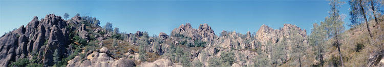
As I hike, I start catching glimpses of the dark-colored pinnacles for which the monument was named. I snap away. The trail starts ascending a bit quicker now as it turns up a small side canyon, then heads west again up towards an overlook about halfway up the trail. I get to the overlook and am impressed by how much elevation I've gained so far, but realizing that I'm only halfway there, and that the longer I linger the hotter it's going to get, I pause long enough only to catch my breath and swig a bit of water before proceeding on up the mountain.
I'm now doubling back along the hillside and I can see way down to where I just came from. "Wow! I'm getting up there". This part of the trail is totally exposed to the sun, and while there were some shading trees at the start of the hike, there is no such relief on this section - I am sweating up a storm! The trail curves around the hill - getting slowly steeper - until I can see what I think is the junction with the High Peaks Trail. "Sh_t!" I still have that far to go (and that much higher)?!" I now rely on an old hiker's trick to get through this stretch - keep your eyes looking ahead no more than a few yards in front of you. Otherwise it's too discouraging. So I try to focus only on the section just in front of me lest I be rendered too weak by the dismay of distance, thinking, "Man! I should have brought more water." Putting on my "This is so easy, I'm having a great time" face, I say hello to a man and his daughter coming down from the other way. Then I resume my plodding and "determined" breathing, - up, up, up.
 Finally, I make it to the "top" and
blessed be, there's a handy dandy tree set up perfectly so as to provide ample
amounts of shade and a big flat rock where I park my keister, giving my tired
legs a much desired rest. "Ahhhhhhh!" I drink in, both a copious quantity of
cool, refreshing water and the grand, 300° view. Beautiful! Rows of tawny and
dark green, chaparral-covered hills receding into the hazy distance all around.
From this vantage there are no discernible signs of civilization, and no one in
sight, and I relax in the solitary stillness. There is a breeze blowing by this
station on the mountain and it feels wonderful, restoring my energy and ambition
as it cools and revives. This spot is perfect!
Finally, I make it to the "top" and
blessed be, there's a handy dandy tree set up perfectly so as to provide ample
amounts of shade and a big flat rock where I park my keister, giving my tired
legs a much desired rest. "Ahhhhhhh!" I drink in, both a copious quantity of
cool, refreshing water and the grand, 300° view. Beautiful! Rows of tawny and
dark green, chaparral-covered hills receding into the hazy distance all around.
From this vantage there are no discernible signs of civilization, and no one in
sight, and I relax in the solitary stillness. There is a breeze blowing by this
station on the mountain and it feels wonderful, restoring my energy and ambition
as it cools and revives. This spot is perfect!
A bit of recuperation and I am not ready to return so soon to start the trip home, so onward and upward I go. Now on the High Peaks Trail, I continue gaining elevation, but am now hiking on the northern side of the mountain and the sun no longer beats so mightily down upon my broad, er... sweaty shoulders. I think it's not so steep either, and I can see what I think is the next "top" - and it's not too far away either. Yayyy!
I round the bend and am presented by the sight of a wonderful and large specimen of manzanita with the most strikingly colored wood - a rich, dark, yet at the same time bright, red. It fairly shouts out at me, so pronounced is its stout, monochromatic trunk, resplendent amidst the surrounding gallery of duller rocks and scrub. At places along the length of the trunk, little pieces of bark are detaching and curling up - as if the tree is molting - adding an interesting texture to the shiny smooth bark. The appreciation of such natural beauty wells up from deep inside, and I am entranced. Captivated even. This alone would be worth the hike up to here. After just standing and admiring for a few moments, I of course whip out my camera to try and capture at least the essence of this sight. Because I have just switched to a "slow" film, I must prop myself against a nearby rock so as to steady the camera enough to not move during the relatively slow shutter speed necessary. Let's hope I was successful.
The trail is flat here and as it curves westward again, another manzanita stands silent and sanguine alongside the trail. As I am now in the shadows I am forced to place the camera on the ground and use the timer. Here, even more of the trunk is "shedding" and I have high hopes for some awesome shots.
I now hit the backside and from this vantage I can see the parking lot of the other side, for there is an entrance from the west, coming in off of Hwy. 101. Just ahead of me is a trail junction and I look, but see no one coming up from below; though there are a dozen or so cars scattered about the lot. The pinnacles of Pinnacles rise high just above me here though, this late in the day, afford no comforting shade. But getting here from the junction with Condor Gulch has entailed little additional elevation gain and I feel quite refreshed actually. I am loving today's trek. All there is to see. The fresh air. The exercise. Everything. What a wonderful way to spend my last day on the road!
 I am now climbing again for the
trial is going right through the pinnacles - squeezing through and over and by
wherever possible. The path here is a series of steps roughly hewn into the rock
- going both up and down - sometime back in the 30s or 40s by the CCC (Civilian
Conservation Corps), when they had a major camp set up to do just that kind of
thing in the monument (the monument was created in 1908). The trail now goes up along a ledge with an jutting
overhang of rock, and I have to squeeze by it and the provided railing, my
daypack scraping as I go by.
I am now climbing again for the
trial is going right through the pinnacles - squeezing through and over and by
wherever possible. The path here is a series of steps roughly hewn into the rock
- going both up and down - sometime back in the 30s or 40s by the CCC (Civilian
Conservation Corps), when they had a major camp set up to do just that kind of
thing in the monument (the monument was created in 1908). The trail now goes up along a ledge with an jutting
overhang of rock, and I have to squeeze by it and the provided railing, my
daypack scraping as I go by.
And then, "Whoa!" I am face-to-face with a wall of rock into which notches have been cut for its ascent (or descent). The rounded impressions left by the cutting/chipping tools used are quite visible, and I can reach out and touch the one at eye level - that's how steep we're talking. There is a railing of course and I grab hold of it and continue on. Or should I say up? I feel as if I am climbing up to the next deck in a battleship of stone, or following in the path of steps kicked into the face of a glacier of rock. It is unsettling yet so cool. The notches - they're not big enough to be called steps - go straight up, then curve to the left and head towards the "front". More squeezing and at last I come to the "top".
 I doff the daypack and plop. Eating
a snack of jerky, and swilling down most of the rest of the water, I rest and
enjoy the view. And it is grand. Though not soaring thousands of feet higher
than the surrounding area, it is still quite a nice perch. Especially given that
it was by no means a great horizontal effort to get up here. Still, I am over
1400' above my starting point. Looking down and to the left I can see the long
switchbacks of the Condor Gulch Trail, upon which I can also see several groups
of hikers trudging slowly along. Looking straight down I watch a pair of bluejays
flying around; creating their usual kind of commotion I suppose. It's not often
that I get a bird's-eye view of birds and I smile, savoring the thought.
I doff the daypack and plop. Eating
a snack of jerky, and swilling down most of the rest of the water, I rest and
enjoy the view. And it is grand. Though not soaring thousands of feet higher
than the surrounding area, it is still quite a nice perch. Especially given that
it was by no means a great horizontal effort to get up here. Still, I am over
1400' above my starting point. Looking down and to the left I can see the long
switchbacks of the Condor Gulch Trail, upon which I can also see several groups
of hikers trudging slowly along. Looking straight down I watch a pair of bluejays
flying around; creating their usual kind of commotion I suppose. It's not often
that I get a bird's-eye view of birds and I smile, savoring the thought.
Looking down at the large boulder upon which I repose, I examine the many differently colored lichens that call it home and make a discovery. What I thought was a dark-colored rock turns out to actually be a light, grayish pink breccia (chunks of rhyolite embedded in a matrix of still more rhyolite while it was still molten). The dark appearance comes from black lichens that almost entirely cover it's surface. Mixed in are many other lichens of gray, green, rusty orange and yellow. Only in the few spots not so adorned does the true "skin color" of the rock reveal itself. Its as if the rock was wearing a colorful, but tattered, lichen suit. Amazing!
Looking at the map, I see that it is indeed all downhill from here, and that I have about 2 miles to go. So, reluctantly, I put myself back together once again and set out for the parking lot. (And perhaps a cool Corona?)
_750.jpg)
More notches. This time going down, which seems more precarious as only the heel of my foot fits in them, and I descend gingerly, holding on to the supporting rail. Then some more "hewn steps" and back again onto the dirt. Just before the first switchback I encounter the first group on the High Peaks Trail with me, coming from the other way. We exchange greetings (trail etiquette demands it) and tell them how far it is to do a loop and that they at least need to go up into the pinnacles if looping is not part of their "Trip-Tik" today.
 The rest of the way down is
easy and uneventful. As I get lower I start catching sight of my destination -
the parking lot with this nice, bright red Explorer in it - and that spurs me on
just a bit more. I decide to save a few pictures on the last roll of the trip,
"Just in case!" Just before the bottom I pass an area for rock climbing where I
can hear today's climbers doing their "Belay on"s, etc on the other side, and at
the bottom I pass a couple getting their gear (carabiners, ropes, chalk)
together as I pass by.
The rest of the way down is
easy and uneventful. As I get lower I start catching sight of my destination -
the parking lot with this nice, bright red Explorer in it - and that spurs me on
just a bit more. I decide to save a few pictures on the last roll of the trip,
"Just in case!" Just before the bottom I pass an area for rock climbing where I
can hear today's climbers doing their "Belay on"s, etc on the other side, and at
the bottom I pass a couple getting their gear (carabiners, ropes, chalk)
together as I pass by.
Finally! I'm back to the truck, where I stow my gear and change into a fresh pair of socks and a clean, dry shirt (feels so good). I open the cooler and, much to my dismay, realize that I drank the last 2 Coronas the previous night. Oh well. There is an ice cold coke (20 oz'er) in the small cooler, and I suck it down ravenously as I drive out of Pinnacles. "Coke is it!" I head south on Rt. 25 to catch the Rt. 198 to Coalinga and the interstate. It's a pretty drive, initially slow and winding, but then opening up quite a bit by the time I get onto 198. I am passed by a lot of motorcyclists going the other way, most in full leathers; some quite colorful. I can see how this would be a fun road to take on a bike. Next time?
198 goes quickly up, over and down the Diablo Range and it's a nice segment to drive, though a bit windy. I drive through a couple of areas where the road is being repaired. I wonder if they are related to the fact that 198 crosses the San Andreas Fault. I suspect so. I note that just south of here is Parkfield - of the Parkfield Bulge - an area that, in the 80's I believe, was "bulging" upwards by several inches; leading to expectations that the San Andreas would cut loose it's stored up strain on a segment along there. It hasn't happened, but I believe that the Parkfield area is among the most seismologically-instrumented area in the world, (if not the most).
 Which reminds me that I forgot to
relate an important fact about Pinnacles NM and the rocks found there. If you go
to the Antelope Valley, along 138 (towards Gorman), to the Neenach Volcanic
Area, you can find the other remnants of the ancient volcano that the Pinnacles
are from - 195 miles away! That's right. The Pinnacles, a very long time ago,
were sitting fat and happy almost 200 miles southeast of their present location;
a compelling testament to the inexorable motions of the earth's tectonic plates.
In this case, the Pacific Plate is moving northwest, while the North American
plate remains stationary.
Which reminds me that I forgot to
relate an important fact about Pinnacles NM and the rocks found there. If you go
to the Antelope Valley, along 138 (towards Gorman), to the Neenach Volcanic
Area, you can find the other remnants of the ancient volcano that the Pinnacles
are from - 195 miles away! That's right. The Pinnacles, a very long time ago,
were sitting fat and happy almost 200 miles southeast of their present location;
a compelling testament to the inexorable motions of the earth's tectonic plates.
In this case, the Pacific Plate is moving northwest, while the North American
plate remains stationary.
I-5 to the 405 to home. What can I say?
And so the trip ends. Man, it was good to get on the road again! I had hoped to take another month-long "On the Road" trip this year - I think every other year is about right - but it just didn't work out. Lucky for me the new Explorer came in a little early, allowing me to take a shortened, 2-week version. If I had a whole month I still would have headed out the same way, but would have extended my travels into British Columbia and Vancouver Island. Well, you can't always get what you want (Hmmm. That would be good in a song...). Nevertheless, I feel extremely fortunate to have been able to travel, and see, and experience all that I did these last 14 days. It has mended my mind and soothed my soul; it has revived me. True, I sometimes rushed past or through. But I also I just sat, relaxed, observed, listened to, and enjoyed. This trip saw me travel to just a fragment of the many wonderful and beautiful places that are out there, just waiting for you to see, to experience, to enjoy - if only you go and travel... On the Road!
Peacefulness.
| National Parks & Monuments: | 8 | |
| Days: | 14 | |
| Rolls of Film: | 17 | |
| MPG: | 17.1 | |
| Gallons of Gas: | 223 | |
| Oz. of Coke Consumed: | 1256* | |
| Miles Driven: | 3812 | |
| Bugs Splattered: | 18,732* | |
| Stars Visible at Night: | 14 Gazillion* | |
| Beautiful Views: | Countless! | |
| * approximate |